20141218 Half Crazy, Half Lazy


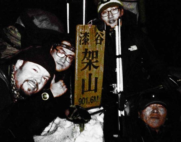
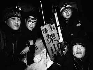
The official first day of vacation is never meant to be relaxing or vacation-like, etc…most of the time it’s spent catching up, be it on sleep or administrative duties (hitting the bank, renewing leases, emptying the litter box, etc) or gleaning contacts on deserted, windswept mountain tops. Today was a day to make it count, like Tuesday, when the formerly closed trails have finally been reopened, well, today was my chance to pay a visit to both HL/JB-017 Unjangsan and HL/JB-020 Gomjigisan. Uh-huh. Another double activation (8+3)+(8+3) and one that I haven’t done since 2012. I’ve been waiting…
When I went down to the car at four o’clock, I wasn’t too concerned–yes, it’d be chilly (chillier, with that nice, sparkling, clear sky) but it is almost technically winter. Isn’t that what it’s been like these days? Having arrived at the trailhead located at Naecheo Village (not at Piam Pass, this time), a local bus arrived a few minutes later: quick jumped out to ask him about the schedule, as I’d like to do something more like a through hike at some point, JB-020 –> -017 –> 027 but getting back to the car would pose a slight challenge, unless I feel I’d be lucky in getting a call taxi to come out. The bus doesn’t go in my direction of interest, but could always be a possibility later on (or going east over Gubongsan…which will become a SOTA mountain with the next update!).
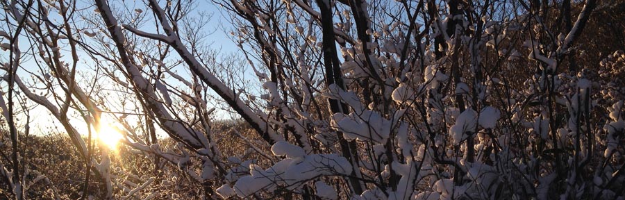
So, I finally get all organized, shoes and spikes on, just as it’s barely starting to get light out when I start up the trail–I’m leaving fresh prints, but that’s to be expected. All is fine and dandy, though as I ascend closer to the ridge (which runs on a north-south axis) I can hear the wind, which I think has actually started up because the sun has risen (energy input into the system). Reaching the junction on the ridge proves me right: yep, wind. No problem, winter, right? It would seem as if the drifts of the other day were a simple appetizer, just a smidgeon of the main course to come…
My main source of surprise comes from the fact that HL/JB-017 Unjangsan is a fairly popular mountain, receiving busloads (really!) of hikers coming to make the loop (which doesn’t get closed off during fire season these days) that culminates between Dongbong (Samjangbong), Unjangdae and Seobong (Chilseongdae). However, the trail did not seem very broken in, at all. Even to the point where I had to break trail in parallel, off to the side of the main path, because of the drifts. The drifts are in the areas sheltered by the wind (hence the snow gets deposited there) and was shallow, guess where? On the windy upslopes a few meters west of the ridge’s crest! We’s gots cold and numbness here in the ROK, but I haven’t thought of frostbite in years, possibly decades. In order to facilitate the ascent, I had to remain exposed to the wind–not fun. Then there are those stretches where you don’t really have the choice but to stay atop the ridge (nice drops on both sides) and face the drifts. Ah, the drifts. Did I mention there were snow drifts? There’s a first time for everything and this is the first time I’ve wished I had snowshoes in Korea: trying to advance, uphill, and breaking through chest-high banks of powder. Seriously? I don’t think there had been more than 15cm of actual snow that landed on the ground, but now it was all right here.

Irgendwie, finally arriving at the summit just a bit after nine, I didn’t wish to fool around and lose the heat I had been generating plowing up the hill (for what seemed ages, but around two hours for the ascent isn’t /that/ bad…it’s quoted at an hour for that trail, can take one and a half loaded down with gear, so I’ll take that given the conditions), so I quickly set up the antenna (5s collinear, as per our “nail-it theme” this month) and set up shack sweet shack in the bothy bag. The actual activation itself wasn’t very punishable, having been completed within a half an hour–quite smooth for a weekday morning.

Despite stunning views in all directions, today would not be a day to dilly-dally up in the activation zone, especially were I to stick to my original plan of activating two summits. I have to say that during the activation, my mind was leaning more and more towards not doing JB-020, but was open to checking it out as far as descending via Kalk Pass–however some of my antenna segments had gotten stuck in the tree while dismantling and sortof cemented the thought that a second activation would not be possible today. That, however, did not stop me from still taking that route (breaking trail should be easier going downhill, no?) plus it should be a bit more out of the wind…

바보…I should know better, as it isn’t all descent, but those places it wasn’t that bad, just a newly developed hole in the side of my shoes was beginning to make itself apparent breaking the banks. Then some uphill through the snow, then down again, until the pass…eh…Gomjigi? Nope, this bear was not going to be crossing that mountain today–I came down a better trail, I’m not going up that path. Down the access road it is!
Five minutes later I am thawed out enough that the thought crosses my mind “maybe I can do it today.” That’s a 400 meter elevation difference talking there–the weather hasn’t changed up there. Besides, my shoes were sloshing around, now that everything had melted. That wouldn’t be a good idea. Moving along, people. Going down this road with its many switchbacks is actually longer, but more comfortable. At one of the curves, I had the impulse to look up–what did I see? The very same ribbon I strung up three years ago marking the end of the shortcut between Naecheo Village and this road (because to follow this road all the way to the bottom, a bit to the east and then back up again to the main trail head and parking lot would add an additional 1.5 km or so). No joke!
Twenty minutes later and I was back down at the parking lot, still the only car there, so I assume the only client of the day for Unjangsan. Not before rustling up a doe just above the farms…

Tuesday Gyeonggaksan


Always love it how people start freaking out when it starts snowing, but it seems to be when it’s too late to actually take some action (despite a bit of snow now and then, haven’t seen a snow day around here…I figure it’s a byproduct of schools conveniently being located within walking distance–for the students, at least). Just the other day my co-teacher came rushing into the classroom at 4:22 PM, to tell me that I could leave early due to the inclement weather. Really. Backstory: my last class at that school finishes at 12:20 and I have free time all afternoon until the sun sets and I am released 4:30 PM when I may go join the hordes of other mindless labourers who all due to any lack of coordination must congest the roads in unison to ensure a punishable return home.
눈오기 시작하면 여기있는 분들 행동 이상하진다–해마다 겨울 오겠잖아요…왜 준비를 안 해요? 눈이 많이오면 학교이나 다른 행사 취소한경유 아직 못 봤어요. 다른 날에 나의 팀강사는 오후 4시22분에 교실에 빨리 들러왔어요: “쌤! 날씨가 나빠져서 오늘은 우린 일찍 퇴근 할 수 있어요!” 정말. 있잖아요…나의 마지막 수업을 12시20분에 끝나고 4시반까지 오후동안 계속 자유시간 있어요. 진짜?
Focus people! Logic dictates that increased levels of sublimated precipitation would be found to my south thus that is the direction of travel which I must pursue. It could also be the fact that it is December sixteenth and all of the trails which had been banned from entry during the last two months would finally be open again–with the gates open, I whole-heartedly rushed into the heart of the storm, splashing nimrods cruising at 20km in their all-season tired non-lit white SUVs with slush as I exerted my full on Pride™ power: 1300cc and 50W on 2m. Three hundred meters up at the Fire Pass, I pulled over and parked at my usual spot.
집중! 물론 남쪽에 더추우면 날씨더 나쁘면 난 반드시 그 방향으로 이동 해야돼요. 혹시도 오늘은 12월 16일이니까 거의 2개월동안 통제되는 산책길들 이젠 열린다–가슴 기쁘고 폭풍으로 들러가서 여름타이어신은 저속 SUV를 추월하고 프라이드™ 파워 300미터 불재까지 편안하게 도착해서 보통위치에서 주차했어요. 스노우타이어도 도워 줬어요 ㅎ

Breezy and snowy would be a fitting description of the conditions as I followed a single pair of footsteps going up the hill…until I reached the top of the western ridge. Let’s just say there weren’t any paragliders today catching some ridge lift… Had I not known the trail by heart, that there was shelter up on top (and have someone else ahead of me somewhere uphill) I’d seriously question why I was up there. Eh, the answer is simple: points is points. I was fully warmed up but couldn’t take off my windbreaker because it was so blustery! There were some drifts already formed, but it wasn’t whiteout conditions or anything, either. Besides, there aren’t any alternative routes on this trail, it’s straight or straight down.
산행을 출발 해서 발자국 1개 딸라서 날씨가 통퐁이 되고 눈이 계속 내려오고 있었어요…서쪽의 능선까지. 거기서 바람 많이 불렀어요! 오늘 능선 리프트 타는 파라그라이더 볼 수 없겠다~ 정말, 이 산길을 안 외우고 위에 대피가 없으면 (그리고 앞에서 어디서 한분이 있고) 정신을 확인 해야겠어요. 암튼 점수는 점수에요. 몸이 참 따뜻했는데 바람 (태풍?) 때문에 바람막이 바찔 수 없었어요! 눈더미가 여기 저기 있었는데 아직도 잘 볼 수 있고 그길에서 다른 길 선택이 없어요.
Upon finally reaching the peak with the fire tower, I left the prints to continue on their merry little way without me (doing the loop course?) while I set up the 5s antenna and retreated from the wind to activate. The last few activations haven’t been that difficult to achieve, QSO rate wise–well today was going to turn that around: it took forever and a half to obtain four contacts, all basically local, with excellent signals.
산불감시초소탑에서 발자는 날없이 계속걸려서 (둘레 코스한다?) 5단지피 설치하고 탑속으로 가서 운용을 했어요. 요즘 저번 몇 운용이 합격하기 그렇게 힘들지않지만 오늘은 진짜 어려워서 QSO 4건밖에 못 잡아서 모두가 그냥 강한 지방 신호들 됐어요.
The descent sloughing through the drifts in the dark was quite pleasant, only catching a few new sets of tracks, some rabbit, some deer, nothing bigger this time around, reaching the car at just a little after seven o’clock. The roads weren’t so bad on the way back that I did arrive at diner’s club on time–what was interesting was that south of the Mangyeong River had the worst of the road conditions but on the other side things were very clear (until getting downtown again, that’s another story).
18시10분에 정리하고 우리 우더운 눈길로 하산을 행복했어요–토끼와 사슴보다 이번엔 더큰 발자를 (인간제외) 보지 않고 19시 좀넘어서 자동차에 도착 했어요. 길거리 월성봉갈때보다 좀 더 좋아서 완주군과 김제에 좀 미끄럽지만 만경강을 지나서 갑자기 도로는 깨끗했어요! 와! 시내까지…ㅎㅎ 그렇지만 화요일마다 만남 다이너스 클럽에 늦게 도착 하지 않았어요!
On top of Jeonnam!

Every direction you turn these days, there’s a wedding…’tis the season! Gotta get’em all done before next [lunar] month–or else…
요즘 어디든지보면 결혼식이 있다…윤달전 빨리 빨리 해야지!
Yesterday, Se-heui tied the knot, so Saturday was out of the picture, thus Sunday really had to count. Problem these days is that it’s technically still fire season, and so many of the possible “double activations” have one of the two summits cordonned off. Luckily enough, down south, just to the east of Suncheon, a nice trio of summits was 100% open: HL/JN–005 Dosolbong, HL/JN-004 Ddalibong and HL/JN-002 Baekunsan. I’ve been to this Baekunsan before, back in December of 2011 with DS4GKA (based in Yeosu), but only that one summit, not visiting/activating the other two.
어제 세희는 결혼 해서 토요일오후동안 거기서 있어 산으로 못 가서 일요일에 가면 진짜 잘 해야 됐어요! 산불기간 아직 못지내서 너무 많은 “더블 운용” 산에 두개중에 하나는 통제이다. 그렇지만 남쪽에, 순천보다 동쪽에 3까지 같이 산 다 진입가능 해요: HL/JN-005 도솔봉, HL/JN-004 따리봉과 HL/JN-002 백운산. 예전에 2011년 12월에 그 백운산에 여수의 DS4GKA같이랑 갔은데 그때에 나머진 따리봉과 도솔봉으로 방문 할 수 없었어요.

To make it all work, I left Iksan at 4AM and 6K5ZLH left Daegu even earlier, to converge at the trail head just before dawn. We made sure to travel extremely light, since we’d have to be climbing into three different activation zones today (minimum 150m x 3, but actually more!), starting towards the west to knock off the shorter summits, first, then descend down one of the eastern valleys after Baekunsan.
어떻게 했나? 먼저 새벽 4시에 익산에서 출발 하고 (ZLH OM은 대구에서 더 일찍 출발 했음!) 산입구에서 (어떤 송어회집앞) 일출저네 만났어요. 오늘은 운용지역 3까지 (150미터이상 오라가기 3번) 예정 있었으니까 침을 가볍게 준비 해야됐어요. 먼저 서쪽으로 올라 가고 제일 작은산 맞이고 계속 동쪽으로 이동하고 마지막백운산의 운용을 완료하고 거기서 계곡으로 하산 함.

Having started just as the sun was rising the going was easy, along a gently sloping forest road before that ended and turned into a real trail, zig-zagging through the creek bed. Reaching the ridge line between Ddalibong and Dosolbong then continuing up to Dosolbong we summitted just before nine o’clock, quickly set up and proceeded to activate in good time, despite the earliness (for 2m, it was early, anyway). Seeing as we still had two more mountains to activate, we couldn’t stick around calling CQ all day, so having completed the bare essentials, quickly packed up and moved along.
일출 뽀면서 우린 편안한 임도로 시작 했지만 도로 끝나서 진짜 산길 달랐어요. 능선까지 계곡으로 (개단도 추가있음) 올라 가서 도솔봉정산에 9시전 이쁜 햇볕 만진 남해 보고 있었다. 장비 빠르게 설치하고 운용을 바로 시작 했음–2미터에게 시가이 좀 일찍인데 운용 문제없이 편리하게 끝났어요. 산 2개 남아서 여기서 하루종일 놀 수없어서 교신 많이 못 했어요.

The timely descent from Dosolbong and picturesque ascent to Ddalibong found us at our next goal around 11. I say the ridge walk on the way over was picturesque because along the way we could catch regular glimpses of HL/JN-/JB-/GN-001 and JB-003 as well as a precariously positioned tree, growing atop a cubically shaped boulder and jutting out horizontally into space (the tree, that is). I had to stop and take it in from all angles.
따리봉해로 도솔봉에서 하산 빨리 했고 능선따라가면서 양쪽으로 보면 완전 멋있는 배경들 볼수있었어요…북쪽을 보면서 지리산 종주를 전제 있었다: 노고단에서 반야봉과 토끼봉 쭈~욱 천왕봉까지 깨끗하게 새로운눈에서 나왔어요! 그리고 중길에서 큰 사각형바위에서 가로의 나무가 기울고 있었어요! 정말 난 모든 방향에서 확인 해야댔어요! 암튼–따리봉에 11시정도에 도착했어요.

Whereas Dosolbong we had all to ourselves, Ddalibong was definitely bustling–especially since lunchtime was approaching, the smell of ramen was in the air! Potentially sacrificing our signal just a wee bit (that portion which would be projected north, that is) we decided to set up on the wooden porch for the convenience of the level/vertical posts with which to use to set up the antenna. Just to the north of this porch and the summit marker was some earth/rock rising up about 3m…thought it wouldn’t matter much, but it did make a difference in the end, as was evidenced in signal reports from Jeonbuk.

우리는 도솔봉 스슬로 지낼수 있었는데 따리봉에서 인간수 더 많아서 점심시간되니까 라면향이 났어요. 정상에서 남쪽방향에서 나무로만든 베란다가 있었어서 저기서 안테나 편리하게 설치 할수 있어서 운용위치 선택했음…그렇지만 바로북쪽에 (마커표나서 땅 아마 3미터 오라왔어 우리 전북 신호가 좀 먹었어요.
Taking into account, reduced signal (just a little), lunchtime lull as well as some snacking of our own (when will I learn not to bring my own food up mountains??? We got all kinds of stuff: more tangerines (I already brought a dozen with me), a huge sweet potato (why not?), etc. Really–the day I plan a through-hike of the country, if I play my cards right, I could really travel light!) this activation took a bit longer to complete. Though, it did work. Then down again, onwards then upwards to the third and final summit, Baekunsan.
모든것을 개산하면: 줄림 신호를 (조금만), 점심시간 주파수의 진정을 그리고 자기간식하기를 (정말–난 생각 잘 하면 밥없음 백두대간 전체 가능해요…오늘은 뭐…감귤 (더!), 왕고구마, 초코, 등) 때문에 이 2번째 운용은 더 오래 걸였는데 합격 됐어요! 그다음: 하산하고 또는 오늘의 3번째와 마지막의 꼭대기 백운산 오라갑니다!

At the bottom of the dip in this last section of ridge lies another forest road, the same which I ascended with DS4GKA back in 2011, and I had half the mind to descend via this route, especially if it were snowy (which it was) having brought a sled to allow the going to go a bit faster…however with our route choices this time around, it was not to be. Either way, it proved an opportune time to crack open and share a nice dark Czech doppelbock that ZLH had lugged up and down the first two summits~!
아래쪽에 있는 고개에서 임도가 하나도 있어요: 2011년에 DS4GKA OM님이랑 오랐어요…이번에 설매를 거의 가지고 왔어요–그대로 하산 정말 빨리 할수 있는생각 했지만 이번엔 산길선택 떼문에 못 했어요. 아무튼 거기서 ZLH의 배낭에 나온 체코 또펠보크 흙맥주를 나누서 조금동안 쉬었어요!

The final ascent on up to Baekunsan was definitely the longest, which is why we saved it for last, to not burn out before hitting the other two peaks! With plenty of chances to take a rest, the view back to today’s previous peaks was quite nice!
우리의 마지막 등반 확실히 오늘의 제일 길은 것, 그래서 마지막으로 예정했어요. 휴개위치들이 많아서 우리 벌써 지난꼭대기의 배경을 자주 볼 수 있었어요!

Baekunsan consistently gives good views of Jirisan, probably since it’s to the south thus the lighting is better…always from other summits such as Deogyusan, etc to the north, most of the time all we get is a silhouette in the distance.
백운산에서 지리산의 보기를 항상 잘 나와요…아마 이 방향에서 빛은 항상 더 좋으니까요. 다른 북쪽있는산에서 (덕유산처럼) 지라산에 보면 그림자 그림만 나와요.

Endlich! Finally arriving at Baekunsan’s summit, snap off a couple photos then set up….only finding a good supporting signpost where I activated in 2011, we weren’t quite satisfied with the signals (or lack of people responding leading to perceived bad sigs), so moved up from the south face up to the crest of the summit, taking turns to hold up the antenna while the other was activating, all to ensure transmission of the best signal possible.

마침내 백운산정상에서 도착하고 사진 몇장을 찍! 찍! 찍고 설치 하고…아이…저번 2011년에 사용한 마커표나무대밖에 좋은때 못찾았지만 (거기서 신호가 그렇게 좋지않았음) 꼭대기바위바로옆으로 이동했고 한명은 교신하면서 다른사람은 폴대를 잡고 제일 좋은 신호 송신 했어요.
However, still it seemed to be difficult, to the point which I was fishing for contacts on the local Echolink node (not successful, but an OM in Pohang was eager to chat) as well as 6K5CSL over in Sacheon (by Jinju) was also trying to rile up chasers for us!
아직도 4국까지 힘들어서 에코링크에서 낚시를 해보고 사천엔 6K5CSL은 우리위에 씨큐 불고 있었어요!
In the end, we did manage to squeak by, wrapping up the whole affair by 16:30, not without observing a helicopter rescue just to the east of where we were. Always some excitement on top of the world!
마지막으로 운용 되였어요–16시반까지 완료, 바로 동쪽엔 헬기구조도 봤어요! 세상위에 우린 심심하지 않아요!

Better luck, this time!

Some in the audience may recall an expedition a few years back to Wibong Mountain Fortress. Or maybe not. Ahem. It was sortof a flop. Kinda. Maybe. Eh…on that occasion I managed to muster up only three contacts, despite having lugged up the FT-857, set up a Zepp,…in the end, the contacts mustered were via 2M on an HT…foo foo.
몇년전에 위봉산성에서 실패된 운용을 아마 어떤분은 기억 할 수 있읍니까? 기억도 안하면 ㅇㅋ…그때에 운용 해봤는데 교신을 3건만 합격 했어요–4개 아니구 ㅠㅠ 또는 난 나의 큰 리그와 단파 안탠나까지 가지고 갔어요: 그리고 그 3 QSO가 다 2미터 HT로 했어요….땡.
Fast forward a few years, time is fluid, no? to redeem myself, having avoided it for a while (“well, officer, the trail isn’t that discernible….also, no summit marker, that I’ve been able to find”)….errr…do such things matter? She’s got prominence! That’s what matters–ignoring the fully remodeled with tended grounds hump across the street, in black and white, this is what counts!
몇년 앞으로 보시면 오늘오후에 완주군으로 이전쟁 맞자워야되었어요…요즘은 지도보면서 그산을 그냥 보기 싫었어요. ㅎ. 이름도 찾을 수없어서 생각 안했어요 (정상에서 아무표가 없고 많은 지도탐색 하면서 못 봤어요–하지만 좀 옆으로 때때로 귀뜰봉 찍었어요, 601미터봉대신 580미터해발 에서.)
이젠 그냥 “위봉산성”으로 이라고 할꺼요–산성벽이 저기까지 올라간다. 미안 하지만 JB-080 서래봉 때문에 맞은편 (북쪽에) 위봉산은 소타된 산 안이에요. 아마 더 이쁜데 그것때문에 위봉산 아직 방문 하지 않았어요. 남쪽있는 산성 그렇게 잘 관리와 리모델링 할 수 있으면 좋갰다!
Previously, I had ascended up the easterly ridge, leading up to the summit from the pass where Wibong’s fortress walls cross, however since it was hairy business going up, I said to myself, “self, the trail goes down over here,” and descended along the non-renovated fortress wall all the way back to the pass. Wasn’t glamorous but it was cleared. This time I went up this route, and with the snow and whatnot, it wasn’t that bad climbing–I just established that I would not be going down via that same route this evening….
저번에 난 동쪽능선으로 알라 갔어요…산책길상태 좋지 않았어요, 그래서 정상에 반대편의 산성별으로 내려는길을 봐서 하산 선택 했어요. 이번 여기로 올라 갔어요. ㅇㅋ. 노프롭램 하지만 오늘은 이도같은 길로 하산 원하기 싫었어요…아직 너무 미끄럽고 걸려면서 벽돌이 계속 움지겼어요.
Upon reaching the summit, I was rewarded with quite a nice view, even if soon after the sun had decided on going behind the one cloud that was in the sky…I mean, c’mon. Really? With hope that this was not a premonition of a repeat performance for this summit, I proceeded to setup my big 5s 2m antenna (eh–it’s served me well so far, this week?).
정상에 도착 해서 멀리까지 이쁜 배경을 찾았다! 몇분 못 지내서 햇볏이 없으졌어요…하늘에 구름 하나만 있었는데 그 구름 하나 해와 위봉사이에 멈쳐서 주차했다. 정말? 양쪽에 모든 다른산들 햇살을 받고있었어요….불운 신호 이라고해…? 아니! 그냥 따뜻한 날씨없는 듯이에요–그럼 5단지파 설치 준비 했어요. (이번주간 동안 잘 썼어요…오늘도~)
Not so fast–there! The wire between the J-pole matching section and the first phased segment broke–well, it is a weaker point in the design, where probably the most stress is exerted when the wind blows (and it does, on those summits!) and things, they all start a’floppin’ around! No, wait! That’s not it–the connection between the two elements (the bottom of the “J,” if you will) had disappeared, donc a bit of surgery was necessary…I removed some wire from the first segment to make the matched connection…if there were any discussion before regarding how much out of tune this antenna was, well, I think we may say in confidence that is more out of tune than beforehand…
앗! 그렇게 쉽게 안돼! 제이폴 매칭아래에 연결선 좀 빠졌어요? 빠리빠리 수슬 해야지–공구 있음…첫단에서 선을 조금만 빌렸어요. 얘전에 튜닝 걱정 있었어요–이젠 더 확실히 걱정 하도 돼요! ㅎ
Such trivialities didn’t hold me back from activating, even if there was a lull midpoint–success was to be had! Yes, it was getting dark, though people do get out of work and hop into their autos for the schlepp homewards….all I have to do it suck it up, call CQ, and wait around.
그런 작은 문제도 있으면 아직도 합격 해야돼요–다른 선택없음. 만약에 주파수 좀 조용이 하면 그냥 기다릴 수 있고 퇴근시간에 모바일국들 나오갰다.
Remember that comment before about not descending along the non-wall (could be called as such?)–well, I decided upon leaving the summit via the east ridge (not the east ridge which leads to JB-070, but the other east ridge, obviously!), through the mini-bamboo…following the trail was actually easy enough, but somewhere along the way down I must’ve gotten distracted, as I was, pretty soon, going over fallen trees and whatnot…I can only assume from 2012’s typhoon: Vol-au-vent (I know, that’s not the real name, but it sounds as such, and I’m too lazy to look up the name at the moment of press–another time! Peu importe, y’all can figure it out….). For a stint. I was crashing over and under fallen trees, snow-smushed mini-bamboo, usw, until reaching the logging road. Skid. Whoops!
아까 전에 나온 다르게 하고 싶은 하산길 댓글 기억 하시죠? 저쪽 동쪽능선으로 (JB-070 원등산으로 가는 능선 말고…) 하산 했어요. 반길까지 편리하게 가는데 2012년 가을의 태풍 (바로밴)
Lost an Eisen: one for the mountain….I ain’t going back to look for it tonight. Maybe in the spring? I know, there’s plenty of moonlight to spare, but I’m happy to be back on pavement, at the moment.
Yes, of course, I did have auxiliary lighting, but why spoil the mood? Nothing like the moonlight on the snow during a northwards trajectory, be it on foot or bike.
On a side note, I was stuck behind a Musso Sports with military plates (육) on the way back…until Bongdong, at least. Was interesting: usually you see the all-band radio-tuned antennas only on the older heavy-duty vehicles–I’m not current, but it seems like they’d be changing their fleet over?
Making the winter bonus worth it! 효율한 겨울 보너스!


On top of Weolseongbong! HL4ZFA/p3
Day three of the new winter bonus period, Wednesday afternoon, northern edge of the province, last class at fifth period and more than a couple thousand unactivated summits in HL for 2014, I set off to the east to ascend HL/CN-012 Weolseongbong from the east, well, because everything from the west was closed (fire season until the 15th…).
이번엔 겨울 보너스 기간 3일 되어서, 수욜오후, 이미 전북의 북쪽에 있었고 5교시 끝나고 운용 아직 안되는 산은 몇천개 남아있어서 HL/CN-012 월성봉 목적지로 설치해서 출발 했어요! 이번에는 서쪽있는 산책길대신 동쪽에서 올라갔어요…아무튼 12월 15일까지 산불기간 때문에 반대편에 등산로들 통제상태 였어요. 
With the snow more or less steadily falling, and actually sticking quite well once crossing over the border into Chungcheonnam, I drove through Nonsan and to the north of Daedunsan Park, entering via Surak Valley (as far as Bogwangsa temple). From the ridge trail starting at the public toilet outside the park gate, by a mini-traffic circle, next to an engraved stone steele citing “dog-shit bug,” hiking commenced around 16:00. It’s actually a colloquial name for “firefly.” Nothing indicating light with that terminology…must’ve lost the flaming bag in translation.
충천남도로 가면서 눈이 계속 왔어요: 논산시지나 대둔산도빕공원 북쪽 계곡을 경유해서 수락계곡 보광사까지 오라갔어요. 공원출입구전에 능선타는 등산로 로정 했어요…수락2리 마을에서 작은 로타리옆 이쁜 돌표 제작했어요: 개똥벌레. 흠. 왜? 공용화장실땜에?

The bathroom was spiffy, not in that music started playing when you walked in, rather that the urinals were all waterless. I’m not concretely sure if I’ve seen waterless in Korea yet…but it’s about time! Note about the product name: when you say “ssh” in Korean, it actually means to perform a number one, and not necessarily to be quiet. Though, in the “why make simple things more complicated” department, I can see this of use in urban locations, but when you’ve got a slew of thirsty trees a stone’s throw away, especially during the dry/fire season, isn’t the choice of action obvious? Serious overabundance of white snow this early in the winter season…^^
사실은 여기있는 공용 화장실 참 괜찮아요–그리고 안에 물 사용하지않은 소변기를 볼 수 있어요. 아니, 원하면 직접으로 사용 할 수 있어요! 이같은것 한국에 자주 보이 지않지만 보면 행복 해요. 하지만 시내에 더 잘 사용 할 수 있고 여기서 숲 바로 옆에 산불기간동안 마른 나무가 좀 “레모네이드” 마실 수 있으면 행복 하갰다~
…at the same time, I didn’t see more than two sets of footprints heading up the hill (none descending). Despite this trail primarily following the ridge, it starts off after crossing the creek along a small gorge, along the way was a pretty serious sink hole, approximately 10m deep, ribboned off. Quite interesting–even more interesting would be to know where other sink holes are currently in formation! A bit afterwards and the trail switchbacks a couple of times to leave the gorge to mount the ridge, from then on quite comfortable walking, technically more exposed, but actually the wind wasn’t bad at all there.
이등산로는 먼저 계곡에 시작하고 몇백미터후 능선으로 올라가지만 위에서도 바람 많이 불지않았어요. 그렇지: 이동하면서 따뜻했어요.
After a while, things do get steep,  before a trail junction and an opening up onto an azelea field, featuring a nice wooden gazebo and a huge boardwalk. One of the drawbacks about heading out in the early snows is that the trail has yet to be packed down…raised boardwalks will have more snow (cooler than the ground) to shuffle around in and you’ll still be hitting the leaf layer on the ground, unavoidable since spikes are necessary (but so much easier!).
1키로미터후 삼거리 지내서 밭에 도착했어요. 오른쪽에 진달래 많고 왼쪽에….몰라. 안개와 눈이 너무 많아서 잘 못 봤어요! ㅎ 이쁜 나무에서 만든 정자도 있지만 햇빛 거의 안 남마서 빨리 계속 갔어요.
Being the first time I’ve approached the summit from this direction, I didn’t realize how close this clearing was to the summit–I had reached the junction at the summit (next to the helipad) within an hour of the start of the hike! Nice!
동쪽에서 왔으니까 얼마나 가까운지 난 확실히 몰랐어요…정상과 헬기장 한시간안에 도착했어요!! 나이스!
Gear this time around included a single-band mobile rig and the good-ol’ 5 segment collinear antenna, with aim to not fail on this weekday activation, and to get back down in short order…in the end the activation lasted through sunset, and I descended a darker trail (still bright from the clouded moon). In fact, the summit was in the cloud. I would’ve activated from my normal spot to the south by the cliff, but there was much less wind on the northern edge of the helipad.
평일이어서 이번에 난 모노밴드 투미터 모빌리그와 5단 지피 안텐나 가지고왔어요. 빨리 설치 하고 교신 8건 너무 편리하게 했어요–보통으로 더 오래 걸을 수 있어요…주말이나 맞는 시간 안되면…ㅇㅋ 정상은 구름안에 있었는데 해발 높고 위치 좋고 신호 잘 보낼수 있었어요.
Eight contacts were effortlessly collected, which was a relief–some days it can take forever and a half just to get four! Pack up, head down…both going up and down it was a nice and quiet, snowy hike, not very cold at all once moving, however it seemed as if the weather was worse at the trailhead, wind and snow-wise.
운용 완료하고 정리 하고 하산 하고….오후동안 눈이 계속 와서 진짜 조용히 한 기쁜이 좋은 춥지않은 산행 했어요. 차에 도착해서 아래쪽에서 날씨가 더 나빠서 다시 집으로 가는 길 오늘의 산행과 운용 더 어려웠지만 전북의 도로는 더 깨끗 했어요. 73!
The drive back was definitely more strenuous than the hike! Though, as if by magic, crossing back into Jeolla, the roads were simply wet instead of snowy, and the going was much quicker! 73!

Out with the old, in with the cold!


Yesterday, December 1, definitely truly proved itself to be the beginning of the winter bonus period in Korea, with a good snowing…even with some starting to stick! Might have to put the wheels away for the winter? Even yesterday’s tea, which had been left behind in the car, had frozen–the change from a very comfortable autumn to “it’s officially winter” was a rather sudden one! What better way to commemorate than with an after-school activation on one of Iksan’s higher peaks, HL/JB-140 Cheonhosan? Registering at exactly 500mASL it just squeaks its way into 2 points and winter bonus territory. Time to cash in, while the daylight lasts~
어젠 12월 01일의 겨울 보너스점수 기간 찐짜 맞으게 시작 했읍니다: 눈이 왔다~! 해마다 날씨가 다르지만 올해 가울이 착했는데….새로운 달이고 새로운 계절은 시작하고 딱 쉬치처럼 이추운것 꼈어요! ㅎ
자동차안에 넣은 차잔까지 얼었다~
월요일의 엄무좀 늦게끝나서 오늘은 이겨울기간시작 기념 해야했어요–익산지역에 HL/JB-140 천호산밖에 다른 맞는목적지 생각 나지않았어요…그럼, 가자!

So, class was finishing up in Nangsan, at the northern end of Iksan, so I could easily cruise on over to Yeosan, up the hill and over the pass that is often snowed out so much that you have to park on one side and walk up the road through the brand-new two-lane tunnel which passes under the pass, and up a bit closer to the ridge line on the northern side of the hill.
낭산쪽에서 수업이 끝나서 바로 여산방향으로 쉽게 이동 했음…이 시골학교 시간표는 평일 소타운용에 편리하게되었어요!
여산 다운타운을 지나서 비봉쪽으로 가서 힘들지 않았다–저번방문 할때는 고개까지 도착못했다–타이어체인도 풑였는데 땡! 불 가능. ㅠㅠ
이젠 조금 낮게 새로운 턴널로 지납니다: 차로 2개 있고 급커브 20개 없고 그냥 쭈~욱! 반대편에 2분안에 도착 했어요!
Despite the frequent snows these last few days, it was actually possible to get up to about 300m with the car on the logging roads–even the parts that were in the shade.
거기서부터 천호산의 ‘노스 페이스’까지 임도로 300미터정도 차랑 올라 갈 수 있었음…눈도있고 그늘도 있는데 ㅇㅋ! (날씨 이렇게 계속하면 아마 담달 안 됨…)

To ensure that I wouldn’t be calling CQ for two hours on this hill on a weekday, I made sure to bring the trusty ol’ 5 segment collinear–despite not having toughened it up for regular use, it’s still holding on. Whether it remains in its original tuned condition is another issue–one I haven’t delved into recently…if I don’t measure it, it doesn’t exist, right?
평일오후에 HT로 2시간동안 씨큐 씨큐 불기 싫테니까 큰 5단지피 가지고 갔고 사용 했고 운용 빨리 빨리 했어요…혹시 이 안테나 상태가
안좋지만 튼튼하니까 계속 사용 하는중–나중에 (항상 나중에…뭐?) 다시 만들고 더 깨지지않는 모델 들어야돼요: 요즘의 튜닝 확인 안했지만 검사 안하면 문제상태 없잖아요 ^^

So, the activation was actually quite quick in the doing, and hands weren’t cold except when collapsing the antenna mast (gloves just don’t grip as well!)–thrice: once for taking some arial photos of the summit, once for resetting the antenna (love it when calling back after your first CQ that the antenna just comes crashing down) and finally to pack up and descend.
사실 준비 잘했으니까 이번 천호산 운용 빨리 완료 되었고 춥지 않은데 안테나 폴대 정리할때만 손이 시렸어요. 3 번. (1번째 “위성” 사진 몇장찍고 2번째 첫 응답 하면서 갑자기 안테나 고장나서 그냥 크래쉬로 내려왔고 3번째 진짜 하산준비 포장 했거든요~)
*그 위성사진들 나중에 붙이겠음….
Well, at least I was back at the vehicle, with daylight to spare! Not an easy feat, after school in the winter!
아무튼, 햍빛 넘어가면서 차에 도착했어요–물론 수업후에 겨울운용하면 이것은 쉽게 할수 없어요!

Bringing in 2013…
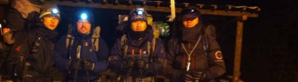
(HL4ZFA / 익순 / 6K5ZLH / DS1OUY)
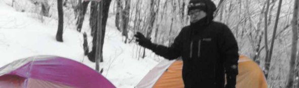
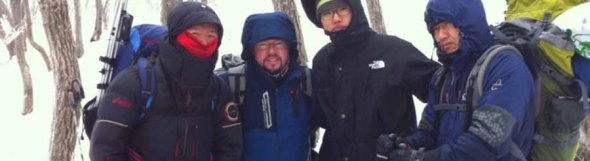
After a bit of run-around, incurring numerous delays (none resultant of my actions–we had actually arrived in Daegu for lunch at 11:59 AM!), we were at the trail head parking lot below 지남문 Gate of HL/GB-068 가산산성 Gasan Mountain Fortress, 익순 (무햄) and I. The event: New Year’s overnight activation, double points, risking life and limb out in the elements….eh, in the time that we were waiting in the parking lot, in the car, each time we opened a car door and the wind took away the heat, we questioned, “why, again?”
Before actually getting on the road, I flexed my 형, exercised my seniority, that is, on 익순. Last time I went on an overnighter with him in tow (fall 2011, JN-001 Nogodan & JB-001 Banyabong) his pack was totally QRO, the thing must’ve weighed 25kg…well you can imagine the results of such folly.
As it was still daylight, I didn’t need to take out my flashlight to interrogate him on whether or not he needed to bring this or that: this tent here? we’re only five and we’ve already got two. Out with you! (Every morning he curses the condensation that collects on the interior of that shelter. Well, that next morning, he would not. Besides, upon arriving at the summit later on, I discovered that somebody else did bring a third tent!)
A full kitchen mess kit? Dude! We’re boiling water to reheat vacuum packed meals and making ramen–be gone you useless mini-pots!
First aid kit, splints, gauze up the wazoo, aerosol cans of something or other, and a bottle of alcohol. Me: “Do you know how to make a splint?” Him: “….no” Me: “버려!”
A second, heavy cast aluminum hand flashlight. “Why?” “Emergency” “Look, we’re five, with five lights–I don’t think all of them are going to die in the next 24 hours unless we get Blair Witched.”
And so it went on, until he was under 15kg–victory! (For now!)
So, we get to Jinam Gate, wait for the others. One was already here, somewhere. Somewhere being over another pass to the west at another trail head. ZLH and OUY still heading up to us. Get a call, “we’re here–where are you?” “We’re here, where are you?” Ah, they were a little higher up, right at the trail head (no advertised parking). Quick, QSY to that QTH.
Get bags ready while waiting for the final member of our team, divvy up the food supplies, anybody need anything else? OK, quick cup of hot coffee–“1, 2, 3: kimchi!” Let’s go.
The trail going up is actually quite pleasant, no steep inclines, actually, most of it is passable with motor vehicle. Despite the moon not having risen yet (was to right upon starting camp setup), the starshine and city lights combined with a snow covered terrain didn’t require our personal lighting to safely navigate along the trail–it was quite pleasant. Note: this primarily works for the ascent since your back is to the lights, whereas heading back down at night the lights are in your eyes and inhibit your night vision ㅠㅠ

By the time you get up towards 중문 the carriageway goes away, and a bit further up, though not difficult, poses just a tad more inconvenience because you’re back out in the wind, and your nicely packed base is covered in drifts–this was only the last 2 or 3 hundred meters, though.
As you can see, we make it to the top, take a couple of snap shots, and head down right below the ridge to set up camp within the activation zone, as the next day was a contest day with the goal of extended operation, we’d want to do it in comfort, right? The wider, grassy clearing was too chilly to use, so we spent a bit of futzing around with ground cloth configurations in this smaller space between the trees.
Once that was out of the way, most were hungry as the evening wore on–luckily we had an extra burner since even though I made the extra effort to keep a gas canister warm, my burner seemed to had frozen or blocked up after an initial flame for a few seconds. Nothing coming out–nada.
With “cooking” underway the antennas (HF & VHF) were successfully erected, with low SWR, and after sausages and noodles, there wasn’t much sense in jumping up and down in place outside….for me, anyways, so I retired to my quarters and started listening to the bands.
Band conditions were not in good shape, even for receiving, so I gave up at around midnight–preferring to save battery power for the morning. 2m was fairly dead, too, and DS1OUY was working that as it was…..just a bit close in proximity to co-operate.
We all slept fairly late, or even if it wasn’t sleeping, stayed in late enough, until 7:30 for the most part. There was the sunrise (see illustration to the right). I was not intent on seeing it–WX was much, much windier than the night before ( = colder), and starting to snow again, but leaving enough in the clear for the sun to poke through at the beginning of the year. Moreover, once you start that in and out 갔다왔다 갔다왔다 you lose all of your nice heat.
No thanks. Not interested. Got at least three more hours of operation left (to make at least four contacts before and an additional four after 9:00, read: midnight UTC).
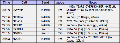
ZLH already had his 2012 points for Gasan, so it was just me working 2m and 40m until 9 o’clock, to cash in.
9 came and went, I gave him the mic at 9:01 for him to start CQing anew. For almost 15 minutes. Nobody.
“Gimme that thing.” I called and almost immediately got 6K5ZFU. Too bad.
“Now our comrades are cold.”
“Eh? Duh, it’s winter.”
“They wanna go.”
“F-me. We haven’t even activated yet, neither have they. I’m OK.” (I’m still in my sleeping bag 😉
아이구. Such an anti-climax after all the hubbub involved with driving over, the hike, waiting through the night, and then this. Whatever, we’ll just have to go back later to take care of business.
Evidently somebody had reduced control over their personal climate during the night because of a missing layer with insulative properties that belonged between a certain sleeping bag and a snow covered, frozen ground. I did double (triple) check at the cars before to see if anyone needed anything. Hey, I even had a second thermarest in my trunk. Foo foo. Can’t dispense TP for the whole globe now, can I?
Packing up went fairly well and quickly–departure, leading to descent, eventually below the ridge and out of the wind, corpses were once again warmed and more relaxed. In the end, even after leaving “early” and not taking too much time in getting down, we had to be back to amazing Iksan sooner than later, so lunch with the locals at the base was not an option.
Perhaps next time. I still don’t have those points for this year, after all…
20120815 구성산
Rainy or not, the 815 contest is a day to be on the air in Korea. This year, not falling on a weekend or creating a longer-ish weekend, being right in the middle of the [work] week, my QTH wasn’t that much a ways a way. Kimje, in fact, via Jeonju, via Wanju. The roads do wind about. I made the effort to bring the 857, principally for the HF bands, including 7 MHz which should’ve been hot, but was not so. ㅠㅠ
Can’t say it was raining the whole time, but it did delay things a bit, and most of the operations took place inside the big red bothy bag. As a result of the WX, there weren’t many others seen on the trail. Fun was had, contacts were made, nothing was broken.
Mandeoksan from the west

You may remember last year when I mentioned how much of a ______ going up the east side to get to HL/JB-058 만덕산 was….sliding up shale, etc, etc….well, though I technically took the better trail up this time, I actually didn’t, having taken the wrong fork not very high up. The result of which was going through an open field trail infested with spiders (you know, by the time August hits, the mommas’ bellies full’o’babies are larger than your thumb), then another shale-y scramble up a deer trail, until finally hitting a decent ridgeline trail.
This time also, I took the 857 since it was a weekday….need the extra push, sometimes. It was worth it, getting some contacts farther out to the south and northeast. Getting up to the summit, it looked like someone had been doing some trimming up there, and signage needs a slight upgrade…. Using the 5s GP, quick work was made for the activation, it was after all, a school day, no time to fool around.

Descent was accomplished via the correct trail, which will be remembered for next time. Maybe next time will be fall or winter, when a machete wouldn’t be necessary…
First 6k0fm activation–비슬산 조화봉

It was definitely a touristy weekend–hitting the must sees, picking up a rental car (SM5), watching “check transmission” messages flash across the dash an hour outside of town, running around to different garages, photo ops in front of this pagoda and on that bridge, rain showers, road construction, LDW, opened up restos and motels with A/C.

First stop was actually at Haeinsa Temple, on the southern slope of HL/GB-001 Gayasan, but with no ascent. Simply wandering around the grounds, investigating what we could of the Tripitaka Koreana through the wooden slats, and cold drinks. (Thanks, Zoom! You’re a good friend!)
We then completed the last leg to Daegu, found lodging, then 고기. Meat with the windows open–don’t we like that? The Koreans don’t take it out to the sidewalks like the Chinese do, but it’s better than completely inside.

The next morning, an early start for Sunday! ZLH came on by to pick me up on his way out of town, heading south into Dalseong County. We were originally aiming for a trailhead at 유가사 temple, but took a wrong turn at 중뫼 and ended up taking the ascent from the Recreational Forest entrance, thus instead of actually heading up to the main peak, we went up to Johwa Peak, which happens to be the secondary AZ just at 25m below the main peak.

Honestly it’s just as well, since the whole time we were engulfed in fog, we were lucky we could get a shot of the national weather administration’s radar tower (see left) visibility was so low. Before activating, we took a gander inside the tower, it’s open for visitors, and I’m sure commands a great view on clear days. Today we didn’t run into 6K5ZPC, who actually works here and has a station set up!
Additionally, the road which leads up to the radar tower (not everyone walks up!) terminates with the highest bridge in Korea! It’s not a mini bridge, either!
Once we set up, it started to rain again, lightly, but not so hard that we rushed through the activation. We had fun making a few domestic S2S contacts as well as giving a CQ Japan call out–with much success! All that on 2m with only an HT connected to the 5s GP!

Well, remembering that others were waiting at the bottom of the hill in town we couldn’t lollygag all day up there, so we went back down the same trail we came up, seeing many more hikers than during our ascent. On the road back into town we stopped to have some cow elbow soup….the cartilage is good for your skin, eh.
Arriving back in town and regrouping, we headed back to Iksan, to return the car and upgrade for a Grandeur. Filling the tank on that thing before was very painful (compared to the Pride), let me tell you!
Still no sign of Weolseongbong…

This date was exclusively reserved to do an activation on HL/SL-001 Dobongsan with the 청룡 Scout group 6K0FA. They had been introduced to SOTA the week before after the hamfest at Yonsei University and were intending on doing a hands-on activation immediately the week after (today). Unfortunately there was a curtain of rain everywhere north of Chungnam with a full day of sunshine Pyeongtaek and southwards. That resulted in scratching that little activity off the calendar.
Doesn’t mean I can’t still go out!

It’s about time I’ve returned to this summit, especially now that I have a better clue about how to go about it than last time! Also, it was actually possible to do this one up and down only in the morning, as both Ji-hun and I had to be back in town for lunchtime.

So, on this 17 of July, we made sure to be there not too much after sunrise, park in an actual parking lot that the village has (completely missed that last time), monumented. Since we parked down there, we had a chance to walk through the village to get up to the main trail head, passing by many of the scenes you see below.

It appears that the village has either a bustling artist community, got some money, or was the subject of some art college’s experimentation. Anyway that you might look at it, it certainly makes for an interesting stroll and is quite well done, in a multitude of media.

Whilst the signage throughout the village clearly indicates how to get up to Barangsan (non-SOTA, but on the way to HL/CN-012 월성봉), once you get on the actual trail the situation is severely lacking. Now, when I visited this very place last year, it was in the exact same condition. Naively I must’ve thought it to be a work in progress, evidently it’s still in progress? Still got those nice extruded aluminum sign posts inserted into ground but no actual signs affixed to them to indicate which way to go about ascending on the less than clear trails.

Hmpf. Not impressed. Especially given the proximity to Daedunsan Provincial Park, to which the trails going over Weolseongbong actually serve as one of the many options to get up to Daedunsan. It isn’t like you’ll get lost, but it certainly isn’t convenient to have to try multiple trails when you don’t know…

Like last time, I did a pseudo-loop, ascending via the same route but intending to descend via the pass but turning off earlier when we saw a suitable trail with others coming up from our destination (where upon arrival we saw a bus!).

We didn’t see any human life on the way up the hill, but plenty of arachnids as well as a couple of deer. There was also a patch of mosquitoes that we had to make our way through (when we were not on the ridge, thus no fresh breeze to keep them away).

For the short time available to activate I made a pretty good number of QRP contacts, not only in the 3 call area around Daejeon but also as far south as Gwangju and to the Buan club out activating Wido Island (I should’ve been there before they rescheduled)…

Equipment for the activation was the FT-857, 5단GP, and LiPO battery (wasn’t planning on being up there for that long, anyways). Next time I’d like to make a point to hit HL/CN-002 대둔산 마천대 from that angle, would be nice to take a new path, and maybe see those mountain goats again.

HL/JB-027 샤티미 연셕샨!

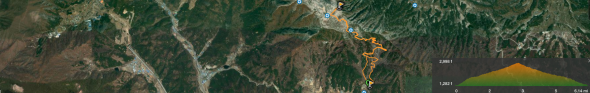
The KMA does it again! The Tuesday morning hour-by-hour forecast had happy little suns all morning except for one hour when there was supposed to be a little rain. In fact, it was the exact opposite. At first it was sprinkling, but me, having checked the weather ahead of time, put off going up the trail until about 6:30. It was a constant drizzle until around the point on the map below where you see the track splitting off into a Y. From then onward, it was a full-fledged downpour! Upon arrival at an outcrop about 100m south to the summit it just stopped, giving me time to set up the 5 segment collinear and let my rain protection drip dry for a bit.

HL/JB-027 연석산 is located just to the west of HL/JB-017 운장산. Their proximity would make for a great double (or triple, if you include HL/JB-020 on the other side, there) activation, especially if you start a little higher up at Piam Pass, hit Unjangsan first (I believe the West Summit might actually be within the Activation Zone, maybe?), then mosey along the ridge down towards Yeonseoksan, to finish up around Yeonseoksa Temple on the 55.

This was a QRP activation, using only an HT with a LiPO pack to power it along I made some pretty good contacts, even down to Jeju! That made my day, especially not having to go at it with 50 watts like in the spring (from much closer to Jeju!) Otherwise the contacts were pretty much in line with what I can usually get (though not bad at all for a weekday morning). It wasn’t even half an hour that it started to rain again….time to break down!

Before making the actual descent, rather, on the way, I decided to verify the second AZ just to make sure it conforms with the rules, and well, it does. It’s not as spacious as the primary Activation Zone, but it isn’t too bad. I continued down along the way to make a tight loop while going down the same valley in which I came up, now once again, in the pouring rain.
I should mention that this valley has some fabulous chilling spots, from Madang Rock (Yard Rock, pictured above) to some swimming holes and water falls farther down, there are some nice nooks and crannies. If I weren’t already soaked to the bone by the time I made it back down I would’ve seriously considered taking a dip!

Aftermarket Ansan Activation


The second Sunday of the month is always a special one. Well, by the reasoning I’m about to present, technically every Sunday of the month is always a special one. It’s hamfest day! The second Sunday of the month just happens to usually be just a tad bit bigger and more bustling than the others, since it’s the hamfest (termed junk 정크 in proper Konglish) in Seoul, in the baseball field at Yonsei University. I like to go when I can, to pander the program and get people interested in SOTA.
Additionally, after this month’s market (July 10, 2011) was a SOTA presentation at the university, which HL1FB so graciously helped to get a room with projector for hosting the event and showing a power point presentation about the program.
Not only was that going on, but also since the main audience was the 6K0FA 청룡 Scout Troop, we planned a hands-on activity with HL1WOU (and DS2NED to help out) to make portable slim-jim antennas with the students for the 2-meter band which they could take home and use on their own hikes when operating portable.


After the antenna activity was complete, the scouts had another engagement to move on to, so I decided to head up the hill behind the University, HL/SL-008 Ansan, for a quick activation before what looked to be rain later in the evening.
It’s a nice short hill, one of the lower summits in the Seoul area, in what amounts to a city park for many who live on its peripheries. I went via one of the back access roads of the university to later descend on the opposite side by the metro station.
When I got up to the top, with a large stone tower and a few people hanging out, I thought it better not to set up the good antenna with all the dark clouds about, so I HT‘ed it so I could get out quickly when it did start.
Even more fun is that 6K2HVZ contact I had–was actually one of the scouts that had been in the group this afternoon!
Good thing I didn’t set up everything, as when I was finishing up my fourth contact, the umbrella came out! Eh, activation complete–hopefully next time it’ll be nicer out for longer. Back to the bus station it was, get a ticket and some goat cheese. Don’t see much goat cheese down in Jeolla, but we do see some goats sometimes….

Seoul On The Air 20110702

(DS1GKD, HL1KFB, N5ATY, HL4ZFA, DS1RDJ, DS1DAT / HL1KKC, HL1IWZ, HL1IYQ, HL2OLP, HL1WOU, F4AAR)
(See 6k0fm.net for the bilingual wrap up of the event, click here)
Big weekend! Thanks to a spark from HL2OLP about a month back regarding an immediate goal of his to activate all 11 summits in the Seoul Metropolitan area (fairly reasonable), especially since after a year of SOTA in Korea they all haven’t been activated yet (one would think that region would be the first to be “ticked off the list” for most given the local demographic.
Me thought to myself that along the same lines why wouldn’t it be possible to stick an activator on each of those eleven summits for an afternoon and make some QRM? Well, the idea took off, and while we didn’t fill up the region 100% we did create quite a racket!

We lost a couple of activators at the very last minute due to a quick date change (rain was scheduled for Sunday the 3rd, so we moved back one day to beat it), but there were also a few random appearances on the hills (not necessarily all in Seoul) but welcome none the less.
Another fun facet of such an event is the points potential, for everybody, not only a wide selection of activators to work from home for the chasers but S2S galore–it was basically a big party on the air–hell, even the cops came! DS1DAT was asked to leave the premises by the military police on HL/SL-004 Inwangsan (military area, open to the public six days a week). That’s pretty much a crap-shoot–nobody bothered me last year when I set up a big honkin’ Yagi up there in the evening (delivered that very same afternoon by DAT himself!).
I chose from the leftovers HL/SL-003 용마산 to activate with F4AAR Laurent–a hill which I had had yet to visit, not terribly low (though low enough to bring full QRO gear). F4AAR brought his newly acquired toy, an SDR radio (a Flex 1500) to do some testing in a hopefully less noisy environment than his flat.
We did have a decent party going on up there, a bunch QSOs in three languages, loads of S2S action, a bottle of red, a freshly made liver mousse as well as some garlic flavored frischkaese. Even though the kit was QRO, the majority of contacts were QRP, thanks to the 5 segment colinnear, we were reaching over into Gangwon-do and down into Chungcheonnam-do.

2차 was happening downtown at a nice charcoal grilled 닭갈비 place (friend’s resto) where propoganda and awards were given out to the top contact makers who showed up–a special edition SOTA hanji pencil cup designed and executed by N5ATY. DS1RDJ took the cake for the top activator (some might imply she has an unfair advantage, all the guys wanting to get a QSO with her….;) with HL1KFB coming in second of those at the restaurant.
After filling up there, we headed through a park and over to a beer joint for 3차, where the imbibing continued on well on after we had to go to catch our (almost last) bus back down to Iksan.
The consensus is that the event was a success, with a lot of people having a lot of fun, likewise with the meet-up afterwards to see all the various activators’ faces in person in one place. It’s safe to say that this will become an annual tradition every year in July for the HL SOTA Association’s birthday! See you next year on the air in Seoul! (Actually, probably much sooner than that…!)

“One just blows through town, one blows the town away…”

…that about sums it up, out for an afternoon ride on the edge of a typhoon (Meari) with warm winds in all directions. With this year’s sort-of early start to the rainy season I was itching to go out, so ripped the mobile whip off the car and stuck it on the bike and headed out (there’s already SMA cabling and NMO mount installed on the bike). It’s nice and liberating to get around and make a contact or two with that minimal gear–
I wanted to take some new paths around the hills and so took a different approach up HL/JB-204 Manghaesan which has a good network of dirt as well as concrete tracks everywhere (besides for ordinary land management, also for the improvements made in the last year to upgrade it as a park not only with trails but adequate signage, furniture and educational displays).

Right as I was making the final ascent up the summit I heard DS3OMA in Daejeon calling CQ so when I arrived up top, caught my breath, broke into the QSO he was engaged in. Unfortunately, while I was in the middle of that contact my back light’s battery died and stopped blinking, with the weather as sketchy as it was and the falling darkness that sort of cut my ride short (I wanted to continue a bit to the north in the direction of HL/JB-201 Hamnasan, but it was not to be). Besides, it was a bit more than breezy on top which made the contact a little more difficult, if not more exciting (and kept the mosquitoes away!)
Anyways, a fun time for possibly the first /bm SOTA contact in Korea!
73 de HL4ZFA/bm

20110618 HL/SL-002 관악산


What a full day! Taking the first and last buses to make three appointments around town, morning, noon and night–who says there isn’t any time to fit an activation in there, somewhere. Four hour window? No problem.
Taking the metro from 신도림 over to Seoul National University, I started on my merry little way, goal: HL/SL-002 Gwanaksan. This way takes you up the western slope, dotted with boulders, and on this dry day was actually quite fun to climb! I’m not sure I’d like to go down via the same route, but it was a fun ascent.
As it’s a bit less travelled, finding the trail head took a bit of a walk, but upon finding it there were no problems. It’s necessary to go almost all the way to the southern end of the campus, going up the Tal, seeing those college-esque sights so common on a Saturday afternoon–banners being painted, bands sound-checking for some performance that evening, though didn’t see any books cracked open on the quad. Those photographers must be very skilled to catch Homo studentis in that habitat…

Arriving at the summit, with weather radars and broadcasting equipment occupying the site, I had to search a bit to find an ideal transmitting location of my own “in the shade.” I finally settled upon a spot just 30 seconds down from the summit on the north side, off the path and under a big rock. QRM down below S3…good enough.
Travelling light and principally with other objectives for the day in mind, I only had an HT, but is certainly doable in the Seoul Metro area. I made seven contacts, easily enough, before realizing what the time was and starting my descent to meet my next rendez-vous for supper before finally heading back down to Jeonbuk. More interestingly, I’d be seeing three of those seven contacts in the upcoming weeks!
I thought I was descending towards the north where there was a subway station at the end of the ridge, but I actually was going east, going together with another group. The path was much wider and worn than that of the one I took up, I was at least halfway down before I needed auxiliary lighting to see, listening to the evening ceremony sounds of the temple on the opposing slope. This path took me right down to Gwacheon station, from which it’s a short ride with only one transfer to get to the Express Bus Terminal. Nice.

미륵산 인 더 모닝

June 16, 2011. Just your average Thursday morning, to go out to your average neighborhood one-pointer that you’ve activated already, like, twenty times this year. In this case, it’s our local “patron mountain,” HL/JB-168 Mireuksan.
So you wake up around 4 AM or so which is normal because your average cat wants to be fed at that time. Or any other time that it wants, for that matter.
The objective, however, on this particular morning is not to feed the cats, but to witness the rising of an almost fully eclipsed moon and observe as it exits the eclipse during the following hours.
As Murphy dictates, it is cloudy outside. Oh, well, maybe it’ll clear up later.
Hop in the car while it’s still dark, hop out of the car while it’s still dark, same-same, teacher.
You don’t hear owls in town. In fact, I didn’t know there were any owls in the neighborhood here–the only other time I’ve heard them is around HL/JB-104 고덕산 just to the south of 전주. Heard them as well as some other hooting beast–though it’s too early for the quail to be out, just yet.
About twenty/thirty minutes into the hike there were other hikers on the trail, not many yet at that hour. It’s early enough that I might go for some HF, even though band conditions haven’t been the best lately.
Get some good European contacts on 20m & 17m, good signals coming out of England, Germany, Portugal and Italy, but the German station couldn’t hear me (above the megawatt Japan stations he was busy working).

As time moves along and HF dries up I move up to VHF, but not before hearing my name…
It’s not even seven o’clock yet and Jerry sees me as he’s coming up the summit on one of his thrice-weekly fitness outings to Mireuksan. What a pleasant surprise!
Though, he’s off as quickly as he came, he does have to go to work, after all. I, too. Just a wee bit later. The kicker is that he’s in my first class of the day!
Alas, after working the locals and non alike, one last bit of HF and I also, am off. The clouds didn’t clear in time, and by now the eclipse is officially over. At the very least, I got some good radio play and DX in a no-stress fashion. On a work day, at that!

Namsan and the QRM monster

So, you say, he definitely didn’t get a full night’s sleep–it was after midnight when he arrived back in town, right? Then there was a taxi ride across the city from Seoul Station over to Dongdaemun, and a few hours snoozing on the floor in the motel room (we sqeeze all that we can in there!)…

Well, let’s just leave it that after getting up and out, bustling over to Central City terminal to lock up the bags for the day and get some tickets for back home, back over to Myeong-dong/Namdaemun market, this time, I was still itching to walk about the park instead of the market with nothing specific to buy this Memorial day holiday.

What’s there to do in the neighborhood? Grab a bottle of water and head up to HL/SL-009 Namsan, bypassing the crowds waiting for the cable car and jetting up the steps. After all, it’s been just about a year (minus a month) since I’d last been around on this one pointer.

Once on the “summit” there are crowds and whatever you’d expect to see on a weekend, so I went slightly to the east to have just a wee bit of space to make some contacts. I must mention at this point, one of the ulterior motives for this 미니산행 was that DS1SLM was up activating HL/SL-001 도봉산 so I thought I’d oblige, give him some points while gathering some of my own…

In coordinating with SLM getting the contact was proving to be on the difficult side, in fact he claimed he could copy me quite well, though I could just barely receive him (we were both operating via HT). After a while, it dawned on me that my receiver was being overloaded from the broadcast tower, which Namsan is. Proceed to find a better place downhill, behind some object to provide some RF “shade”…this was hard, I was putzing around behind trees, stone walls and the like, when almost giving up, I tried heading back up the hill to under the tower.

Last year, without thinking, we simply sat down in the shade with some cold drinks (thanks, Zoom!) in the terrace café under the N-Tower, overlooking the city, the river, up to HL/SL-002 관악산, etc. Duh, we were perfectly in RF shade, directly under the antenna firing out horizontally. QRM was at peak S3, but mostly S0.

It was from this QTH that I had my final activating QSO with DS1PRD, across the river, discovering that he’s actually from the Iksan area! After that, I gave a few more CQs at 1W with no response before the battery was fully dead (remember that ultra-long hike yesterday?).


I’ve never really had the time to piddle around Namsan Park (still haven’t), so decided I’d descend via a different route, going more to the east to take the rubberized road down (the first time I took it, I went the wrong way). To this point, I still haven’t figured it out, actually. It’s not straight up or down, there are maps prominently posted along the way, but half of them in braille, not even any Korean side by side. In the end, I took a nice “short cut” of wooden stairs cutting through a ravine leading down through the trees.

This wasn’t before first paying a visit to the geographical center of Seoul, conveniently located smack-dab on top of the city’s mountain. Depending on who you ask, it could very well be the center of the universe ;p

In addition to the cable car, another means of transportation to the top is a fleet of electric buses which happen to have a charging station located a few hundred meters down summit.
Alas, a good way to unwind the rest of the way at the end of a three day weekend. Though, in all seriousness, my recommendation to future activators is just to chill on the terrace in the shade for a leisurely “armchair activation.”

Korea QRP Club outing

Activating HL/GW-001 설악산 on June 5, 2011 was an endeavor that took about 25 hours. HL1KKC and his Korea QRP club arranged this trip, last time having done it in 2007. After having trucked up to Seoul and meeting 6K5ZLH (who also had to find his way up to the Special City), grilling and eating some porcine flesh on the sidewalk with N5ATY, we took the subway to the other end of Seoul to meet the others at 11 PM and hop on their bus that they had out for the excursion. It was well arranged, we arrived and literally thirty seconds later it was like “here’s your beer, the meat’s on the bus, hop on and grab a seat.”


You’ll note that the departure time was quite late–that being because our hike started quite early: 3 AM. We arrived at the Hangyeryeong Rest Area sometime around 2 o’clock to eat and get ready (this wasn’t our point of departure, rather our final arrival point later on that day). The place was crawling. No place to park, the food stands open and running, the bathrooms steaming, traffic not flowing, really. It was hopping more than those huge pullovers next to eight lanes of traffic at the same time!
We got back into the bus and started on our descent to O-saek Yaksu (it is lower) twisting and curving along the road until hitting this other “rest area” though not the area proper. There was a good quantity of people milling about, and even though it wasn’t quite three o’clock yet, the trail was open and one could just barely see the lights bobbing up the hill in the trees.

The way up was actually quite normal, just a bit longer (it is a trot up to the top, there!), we took a couple of short breaks on the way up, and upon arriving just below the summit at maybe a quarter to seven, out of the wind and waiting for the rest of the group, HL1WOU already already had a slim jim thrown up into a tree and was making 59 QSOs to Seoul, 140km away with his HT. We had to wait out of the wind, because although we may had been hot at the bottom it was actually quite chilly (very chilly?) up on top!

At about ten after seven, we had everybody amassed together again, and set out to brave the crowd on the summit. This is seven AM, not New Year’s morning, and there’s a crowd. On top of Seoraksan, Daecheongbong, there are actually two markers. For each marker there are two lines: one for the photographers, one for the photographees, naturally the two lines advance at the same rate as you have things pre-arranged with your group. Hence the two summit shots above, and not necessarily with everybody coordinated together!
I chose “the sunny side” of the summit to set up initially, it was in fact sunnier, and a bit less breezy. I actually activated from that position, making my first four contacts of the day, including with Mr. SHC who was starting out on his way to that very same summit from a different point down below!
After these first QSOs, we decided to move more over to the westerly side of the summit, finding a rock from which to operate behind, out of the wind, a decent location for the antenna, also.

Much of activation was conducted using five watts, CQing at higher levels to break through people’s squelch at home–however, for those closer contacts that were more tucked into the hills the going was tough even at fifty watts (though almost 300km away to Iksan on five watts brought me a 55 report–that’s with no GP, no Yagi, just a two segment mobile whip!)…
6K5ZLH and I operated on and off until about half past eleven local time to both activate. We were graced by some visits, first DS1RZP, then DS2SHC. We then packed up and headed down to the shelter where HL1KKC and his crew were operating, getting lunch ready, eating or napping in the sun. While down there and catching up on the news, we found out that evidently a hiker who also took to the trail that morning didn’t make it up, having a heart attack on the trail (there are some warning signs at the more popular high peaks outlining the dangers, which are more present at the “must see” destinations that see a much broad range of skill sets attempting the trail). Actually, later on in the afternoon during the descent we saw another rescue helicopter out looking for somebody–not sure it’s increased risk or simply an increased quantity that shows the normal risks that exist at any time.

At one o’clock, after having taken the group shot below, we started our descent, rather, what I thought was to be our descent. Hangyeryeong is a few hundred meters higher up than Osaekyaksu, but the path there is still a good distance. There were a few times when we passed markers indicating our elevation was “currently” 1300 meters–wait, we’re supposed to be coming down from 1700 to 800, when’s it gonna happen? We had quite a few re-ascents right up until the end (I can’t say it wasn’t an interesting trail…some of the views were quite spectacular), then four hundred meters of drop all in the last (less than) two kilometers!

Though ZLH had so graciously offered to truck the 12AH SLAB both up and down, with the 857 and other equipment I was still eager to lose that heavy load, hence my lack of excitement when the reality of the “downhill” came about 😉
At the bottom after a nice cool head rinse, tea and re-hydration spirits were much higher again.

Eventually, everyone made it down (gravity happens) and the fully loaded bus started moving west, only to pause a while later once we got out of the mountains for the obligatory 닭갈비.
As for the rest of the trip, I don’t think much was remembered by anyone, as everybody was sleeping until we got to Seoul, dropped off by Seoul Station at half past midnight…such a late arrival wouldn’t even be enough to stop me from even a mini-activation the next day…

Half-holiday at 계화


A Wednesday morning. No class. First day of June. Sounds like an opportune situation to get a head start on some good figures in the stats!
Technically, this should’ve been a double activation, first a quickie at HL/JB-199 계화산 then a quick scuttle over to HL/JB-196 석불산 not more than 4km away and just as short. However, the more that I try to operate in Buan or Gunsan, the more I’m starting to believe the Saemangeum might have an effect similar to the Bermuda Triangle…you’d think being way out in the open and away from everything there’d be nothing between me and those QSOs!


Well, I must’ve spent the first three hours of the activation draining my battery calling CQ on 20m, likewise on 40, a little bit on 17, and also on 2m. No love. The wind took down the buddistick twice, maybe, and keeping the big collinear up, well, let’s just say I was kept on my feet. Also, the tuning was knocked out as my phasing spacers were tugged this way and that.
Of course, when I was packing up the antennas and ready to bag the whole activation all together (not a single QSO!) I hear someone calling on the highway from across the summit where I was…quick-like get over there to answer!

There was then the rush of a half dozen contacts, running continuously (everybody on lunch break?), everybody asking if I had had lunch yet (nope, but was meaning to ASAP). In the end, the activation was saved, but I had nowhere near enough time to even consider heading over to Seokbulsan! It’ll be next time, then perhaps I can hit the filming studio they’ve got over there, too.

Just for the fun of it

On the theme of getting out when there’s a chance (we’re not speaking of skipping class or anything, here), I went out tonight (20110516) at 6 PM local time for a bit of 야간산행 action at good ol’Mireuksan JB-168 (well, it wouldn’t be quite so brilliant to wander about at night on a trail I’ve never broken before, eh?).
I took a bit of everything, gear-wise, to the top to play around with in the moonlight. This means the newly built 5 segment collinear for 2 meters, as well as the buddistick kit for HF to take advantage of the evening hours. While setting up the HF kit, I checked into the local Jeonbuk net (every Monday night at 8), easy with the HT from a height like that (can’t do it from the 10th floor at home, have to go up to the 15th or 16th floors to get above the HAAT created by all the flats so ubiquitously arranged about).

To stretch out after finding a frequency and spotting myself (data charges, here we come!), I used 20 meters, with the buddistick grounded through a nearby tree, and as my second contact just barely heard a GW call through the noise, though after working it this way and that we managed to get the bare details through, GW4BVE in Wales who could evidently hear me quite well (54) is quite the accomplished chaser. Immediately after I had another rough QSO with an Austrian station. When BVE later came back his signal greatly improved to 57, but couldn’t catch any more European calls on my end.
To wrap up on 20m I had a couple of contacts in the more usual circles of Taiwan and Russia, in Taiwan being another 100th anniversary station (just chatted with one on Saturday) and in Russia up far north above Japan.
Back onto 2m with the 5단GP and made some pretty decent contacts up into Cheonan, Seoul, Daejeon and locally. The contact with the Seoul station reminded my why I picked up the book for the Korean license test on Saturday–I must’ve been involved in a ten minute conversation with this station (not a new station, either, holding an HL call!) and not once during the whole time could he grasp my call (not an issue of signal quality, either, to hold a QSO talking of the hike, weather, with all copy on everything else, etc). All the more reason to study!

Things started calming down after ten o’clock, and then this threesome arrives rather noisily at the summit–college aged, out for some exercise, but no water! Sure, you can have some…in the end when I had packed up we made the descent in parallel meeting up at some points where the paths crossed on the way down.
Not bad for a Monday night on the C course!
낏대봉 no-namer & the 5단GP


Today we had some business to take care of in Jeonju, me picking up a book, my XYL learning some hanji techniques. What a perfect opportunity to tackle a nice short summit nearby…I can be in and out in just the afternoon. HL/JB-155, a no-namer with no precise altitude known was a prime candidate, to find out some answers.
Mistake number one: just because it’s a lowly no-name one pointer doesn’t mean it’s going to be a nice, quick outing! Getting out there was easy enough, it’s not even a five minute drive from the Hanok Village in Jeonju, where turning off the 17 before it meets the 21 to go up a small valley I stopped to ask some locals that were hanging out just what is that there hill called? Ggitdaebong was the answer. Big help that is, as it’s one of the generic hill names that one can often encounter in Korea. Whatever, I’ll find out better, perhaps, if there’s a marker on the summit or something. (none of this info is on any maps I could find, and the summit height isn’t marked, but some other arbitrary summit height is marked, etc)
I continued up the road past the smallish reservoir as far as I could go, ending up at one of a few grave sites. Normally there are trails in these areas, and there in fact were. I took one that led to one of the other sites, trying to go up as quickly as possible and avoiding detours, as I had gotten pretty close (~700m lateral distance) to where the summit was. (Mistake #2, the closest start point isn’t necessarily the easiest or quickest).
Heading upwards on the trail which was, in fact, going in the complete opposite direction of my goal, I turned off onto another track leading directly up. Just barely a track. Luckily the undergrowth hadn’t started in quite yet, but the ground wasn’t terribly firm. After some ways, I did hit what looked to be a main trail, especially since it ran along the ridge line. This kind of trail would’ve been more convenient to have found at the bottom (wherever that may be, still being unknown at this present time).
Progress now was much more quickly paced, until I got within 50m altitude of the AZ and a junction, the choice to go towards the highest summit (and descend to get there) or up to this particular summit. I chose the former, though now I wonder if the trail would’ve been better if I had gone by way of the latter….the trail itself wasn’t an incline rather ran along a steep incline so it was a foot track barely one body wide, easily eroded, and not very clear. To make a long story short, at some point I had to scramble up to the ridge to get back on top of things, displacing more topsoil than I really felt was appropriate.
Afterwards, I was back on the fast track, walking along something definitely more worn, even passing a junction that I believe goes down to the temple on the north side of the hill. Then I found the summit, even going to the next mini-bong to make sure that it was the real summit. Surprise, surprise, the actual height of the summit is higher than our original estimate that went into the database, clocking in at around 502-504m ASL. Following that nasty-ish hike up, it was a rather pleasing discovery as I feel if someone were to make all that effort to get to the top and only claim one point it would be wrong. So, when the next ARM update comes out, the scoring, name, as well as lat & long for HL/JB-155 will be adjusted accordingly.

Seeing as one of the goals of this particular trip was also to test out my newly built 5 segment collinear antenna (5단GP) for 2m designed by M0GIA (ex. M3FVB). His design was originally for a 4 segment antenna, but figuring I had a ten-meter pole with which to raise it I could lengthen it by one segment, also as I wanted to construct it from one single wire and the length I could get my hands on was 10m long, it was just long enough for five radiating elements and four phasing segments.
As the wire wasn’t very stiff, I formed the phasing elements with plastic from some cat litter containers (the green portions in the photo above of the antenna). The matching section is made of two segments of threaded stainless stock to allow for easily fixing the contacts after tuning. The wire itself is .75mm2 stranded copper (~20 gauge?).


I set up the 5 segment antenna alongside the 2 segment Diamond NL22 (8dB gain, no ground plane mobile whip), for comparison (additionally I had an extra HT for reference.) Like I said, I was expecting an easy hike and for the testing wanted to put forth all possible conditions, otherwise I wouldn’t have brought three rigs! ㅋㅋㅋ
At first CQ I started swapping things around while talking with DS4OVT in Gimje, though honestly he wasn’t paying too much attention to my outgoing signal and was more distracted by the differences in how the different rigs’ mics sounded (once again, the VX-170 gets dissed 😦 though that was in comparison to the FT-857’s stock mic (just wait until I set up the base station with an SM57!) however in some of the operating conditions it sees I’m not going to mod that mic and decrease its water-proofed-ness). I’ll have to have somebody on the receiving end record throughout testing next time to see with my own eyes what’s going on.
Post Script Edit:
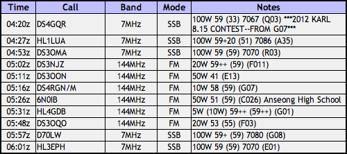
The following Monday (May 16) I took the 5단 GP to HL/JB-168 for a spin, with only 5W DS3OMA was receiving me 52 (and I he 55 with his 10W) in Daejeon, 45km away. However, just the other week, June 15, using the Diamond 2 segment mobile whip, I was receiving him 51 (no changes in his system), and he I at 52, yes, still the same report for my signal but I was putting 50W into that antenna! In the first case, I did stretch my legs in testing with him up to 50W which he says did peak at 59, so that must indicate something done correctly with that antenna!
Anyways, between making some more QSOs on 2m, and then some on 20m (with a 100-anny Taiwan station, not my first, not my last!) and back on 2m again, I made a contact to remember with DS4GOD on HL/GJ-001 무등산. The kicker is this: normally the top 200m or so is closed off, being a military installation and all, so unless you’ve got connections, activating is out of the question. Well, today, for the first time in 46 years, during a six-hour window, the general public was allowed to reach the summit and it was at this time that I had a contact with DS4GOD as he was on top of this mountain. I’m so jealous–had I known ahead of time, I would’ve gone down there myself to activate! Either way, I caught some “SOTA DX” thanks to him!
I packed everything up while waiting for DS1SED/p4 to reach the summit of HL/JB-017 운장산 (I had already heard from him on his way up) to make a S2S before heading down on my own. We had our final contact, agreeing to meet later on in the evening as he’d scooter on back to Jeonju quickly enough after he activated (a last minute affair, on his part).
Playing it safe, I decided to take the beaten path down (knowing there are cliffs if I were to attempt a “direct descent” bee-lining to the car. Heading east, around the rim, it wasn’t too bad, nor was I worried with the adequate lighting I had on hand. It was more a matter of not taking too much time to be back in town to, like, eat, and stuff. Well, after making my way down, going under the newly constructed 27 expressway (Wanju-Suncheon) I arrived at the village just to the south of where I originally drove through to get to the trail head. As chance would have it, there was an old guy walking out of his house, heading right on over to that next village to have dinner at his son’s house. Well, ahem, he just couldn’t keep his hands to himself–groping towards my privvy-parts and asking me if all “Americans” were this “well endowed.” I dealt with this for about the five minutes it took to get back up to the other road with which I was familiar, discreetly fanning him away, listening to him explain how his son studied abroad, how he’s the same age as me (not the old guy!), etc. I did make it back to the car, and headed back into Jeonju to a schnitzel joint to dine with my XYL and some Parisians she met at the hanji shop.
2차 was meeting DS1SED to hang in a 휴게실 out in 효자동 for some beers and squid (outside of which was that tree converted lamp post you see up and to the left). It had been a while since last meeting, so was enjoyable. Going back home we took the 나티 대리운전 service which was more comfortable than the normal joe’s you call to grind your gears and get speeding tickets for you.
Sur le BS–pour 200 points!

For my first ever activation in Busan, and final activation for the long weekend, I chose to pick my fight with 금정산 HL/BS-001, the highest summit in the Busan metropolitan area. Activating this summit, Godangbong, pushed me over the 200-point mark–and it’s surprising how much more quickly that second batch of one hundred points seemed to pass by than the first one (though the time frame is roughly the same)!
고당봉 is located at the northern end of Geumjeong fortress, and I chose to access it via Beomeosa temple, first taxiing it up to the temple then catching the path there for the remaining 3 or so kilometers to the top, passing through the north gate, aptly named 北門. Skipping the bottom leg of the trail was partly because of time constraints as well as to not use all my energy before the next day’s (Sunday) ARDF event also being held at the fortress. I now know that this was a good move since down below it was much hotter, even as far up as the temple, but once I was about 200m higher than the temple the temperature was much more tolerable and fresher.
For the walk itself, I wasn’t sure what to expect, as the particular reviewer who had covered this part of the “Busan experience” in the Lonely Planet Korea took, let’s say, a negative stance, basically dissing anything and everything about the mountain and surrounding fortress. While from my only previous experience of Busan I can’t say I gave the best evaluation of the city either, however when wandering around this area (for two days, at that! Including the ARDF on Sunday) I have to say that I liked the fortress, and found the facilities to be perfectly adequate. I was duly impressed by the city’s efforts at renovation, plus the “solar trail markers,” but I’m still trying to figure out why, exactly, they were solar (I wasn’t around late enough to see if they lit up or anything)… Maybe the person was expecting a cable car to the top, a kiddie train, and a changing of the guards enactment to videotape with a shaky hand never to watch again as grading criteria.
This was planned to be a VHF-only outing for a couple of reasons, one with the intention of a S2S contact with DS2NED on HL/CN-004 O-seosan, and also to make some local contacts in the area. Additionally, since it was a Saturday afternoon, chances were good that somebody else out and about on a mountain somewhere would have an HT turned on.

Upon arrival at the peak and photo shoot I set up the 2 segment mobile whip I was to use and set about scanning the dial, firstly looking for DS2NED. While scanning the lower segment of the 2m band (in SSB) I came across a signal, which was actually HL5BSS having a QSO in AM with someone else who I couldn’t hear–I tried to make contact but wasn’t too successful. Though that was an interesting experience. Moving back up again in FM, I came across NED‘s voice, and sure enough it was him, coming in 58 from the top of Oseosan. I got in line and had a quick contact with him before he took a break to have a bite to eat, said he could pick me up at about 57 over there. Not too bad, as it’s almost opposite ends of the country!

Over the next couple of hours I had a steady stream of contacts all around, west to Gimhae and Changwon, north over Ulsan and Gyeongju all the way up to Pohang and towards Daegu, not to mention down town with a bunch of locals. I also had some QSO’s with a bunch of OPs who I’d see on Sunday at the ARDF race, including a few who were out setting up the course around the fortress for the event in advance. I would’ve kept going but was already late for the planned dinner arrangements so had to cut things off at 6 o’clock (and the battery wasn’t near dead yet!) and head down the hill back into town…

Upon approach to the north gate in scaffolding, it was plain to see people were hard at work here. There was a caterpillar moving rocks up and down the wall to the east of the gate. On the other side (the inside) was the indication (on the right) indicating the phases of renovation that the fortress is undergoing (will undergo) until 2026 (that’s a ways away!). There was also a stone shop where they were cutting and chipping new stones for the fortress walls. It seemed as if they were using a rock saw for the basic shapes then chipping them down to size in addition to giving the blocks a more rustico appearance.
While at this workshop I got to see the “forest fire horse,” a man (ranger?) riding the trails on the horse sporting a “산불조심” emblazoned banner over its mane.

Taken from another sign whose image I couldn’t get to come out in the photo:
Its tip composed of a huge granite mass, this peak of Godang-bong was named after Gomo, a goddess of heaven, who according to a legend based on Taoism, came down here to become the goddess of the mountain (there is still a praying place called Gomodang near the very top). This is the highest of about ten peaks on Mt. Geumjeong with a huge dragonhead-shaped stone called Yongduam at its breast part and a shallow well called Godangsaem at its southern waist part. At its eastern waist part lies a spring called Geumsaem or Geumjeong [金井] (which literally means ‘a golden spring’). A legend says that a golden fish came down from the world of Brahma [梵天:Beomcheon] in a five-colored cloud and lived in the ‘golden spring.’ The names of the mountain (Geumjeonsan) and the temple (Beomeosa) originated from this legend.

Another 74 in 24

You know you’re in a farming town when you’re out in the street at 5:30 am and you see more people out than you’d see at lunchtime…folks milling about, rambling down the street on their tractors, etc. Sangju decidedly has two crowds: the locals and everybody else (tourists and whatnot). I wouldn’t expect to see the others out of doors until after nine. In fact, my little tourista 😉 wasn’t up until ten, let alone out the door.

Anyways, I left the “Big Pine Motel” (sounds really redneck, eh? literally : 큰솔장) early to get a quick [unplanned] activation in at HL/GN-074 금산. The intention was to do this yesterday, but due to the holiday and everybody who was out, I couldn’t even get to the main parking lot, or even the ticket booth! Traffic jam at Geumsan! We just turned around. This morning, cruising up the road, I had the place all to myself, saw very few souls, and not until reaching the upper parking lot. That’s in fact the reason why this was set aside for a quickie not to get in the way of things too much: there’s a nice road leading up to a secondary parking lot at about 600m ASL.

Now, why a mountain would have a lot that high up is beyond me, but the Bori-am Hermitage there is quite the popular destination. I know, the engineer who planned the place with paved roads and parking lots should be shot as he clearly couldn’t bother to look up hermitage in the dictionary. The point is, it is still quite convenient to be able to get up that far and walk the last kilometer/ascend the last 100m if one is pressed for time. Moreover, I’m sure if one’s in the loop with one of the monks, you could probably get past the barriers and even closer.
Seeing the sign extolling the dangers of lightning (first time I’ve seen one of them around here) reminded me of our return to the warmer months, bringing with it mosquitos, spiderwebs and thunder bolts to chase you off of summits and foil activation plans…

Around 6:30 I arrive [very comfortably] at the summit, Mangdae, with a nice stone tower built to hold signal fires. Fun, as I was there to do some myself. Even though the weather wasn’t as clear as it was yesterday, I could see quite well down to Sangju, as well as to HL/GN-274 만운산 where yesterday’s activation was (view above).
 I figured that since it was so early, VHF wouldn’t be my best bet to get contacts, so proceeded to set up the buddistick for 40m. Ironically enough, all of my QSOs, HF or otherwise, were domestic, starting off with DS1SED/4, we went through some tests going up to 100W and down to 5W where he could still copy me quite well though might night get many takers as I called CQ. I made one closer contact to Daegu at a full 100W as he had trouble copying me, then the rest of those I talked with at farther distances I had the luxury of going at only 20W with good reports all around.

Once eight o’clock rolled around and the summit activated on 7 MHz I decided to turn to VHF for the last portion of the activation before heading out, as the people were increasing in number and just maybe a smaller antenna would be less weird (who am I kidding, right?). I started calling CQ and had a steady stream of takers near and far (even YOP on one of his routes!) at varying power levels including DS4GQZ on the rooftop of his office with his HT in Suncheon and over to Busan, also.

During the course of the VHF portion of the activation I met one inactive ham on the summit, though hopefully he won’t be inactive for long! After packing up, I took a detour to check out the hermitage, then continue on my way out. The ride down was uneventful (brakes still good, low gear descent charged my SLAB 😉 but the traffic was already backed up at the ticket booth a good half mile.

Back at the Big Pine Motel I had my second cold shower of the stay (I had already mentioned this to the owner last night, it still wasn’t fixed/turned on/joke finished/whatever this morning but I stink/stank/stunk). Afterwards it wasn’t the first time I looked up the hill asking myself why we didn’t try overnighting at the 찜질방 in Sangju. Evidently we weren’t the only ones to be disappointed with Sangju’s Silver Beach. At least we saw goats, though! Also had an assemblage of sashimi for lunch up the road!


