On top of Jeonnam!
Every direction you turn these days, there’s a wedding…’tis the season! Gotta get’em all done before next [lunar] month–or else…
요즘 어디든지보면 결혼식이 있다…윤달전 빨리 빨리 해야지!
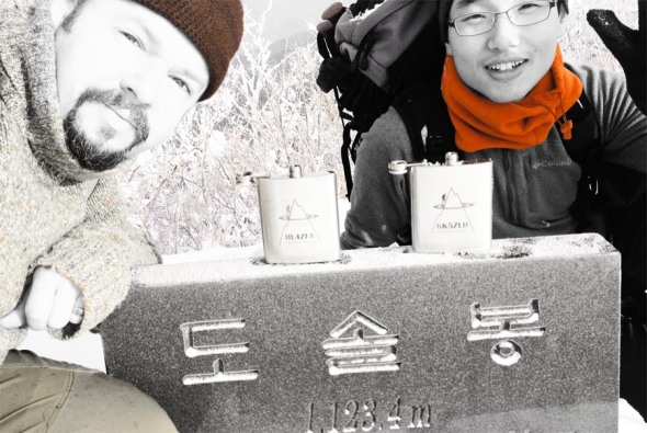
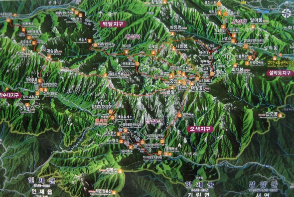
Yesterday, Se-heui tied the knot, so Saturday was out of the picture, thus Sunday really had to count. Problem these days is that it’s technically still fire season, and so many of the possible “double activations” have one of the two summits cordonned off. Luckily enough, down south, just to the east of Suncheon, a nice trio of summits was 100% open: HL/JN–005 Dosolbong, HL/JN-004 Ddalibong and HL/JN-002 Baekunsan. I’ve been to this Baekunsan before, back in December of 2011 with DS4GKA (based in Yeosu), but only that one summit, not visiting/activating the other two.
어제 세희는 결혼 해서 토요일오후동안 거기서 있어 산으로 못 가서 일요일에 가면 진짜 잘 해야 됐어요! 산불기간 아직 못지내서 너무 많은 “더블 운용” 산에 두개중에 하나는 통제이다. 그렇지만 남쪽에, 순천보다 동쪽에 3까지 같이 산 다 진입가능 해요: HL/JN-005 도솔봉, HL/JN-004 따리봉과 HL/JN-002 백운산. 예전에 2011년 12월에 그 백운산에 여수의 DS4GKA같이랑 갔은데 그때에 나머진 따리봉과 도솔봉으로 방문 할 수 없었어요.
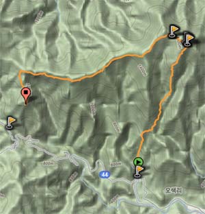
To make it all work, I left Iksan at 4AM and 6K5ZLH left Daegu even earlier, to converge at the trail head just before dawn. We made sure to travel extremely light, since we’d have to be climbing into three different activation zones today (minimum 150m x 3, but actually more!), starting towards the west to knock off the shorter summits, first, then descend down one of the eastern valleys after Baekunsan.
어떻게 했나? 먼저 새벽 4시에 익산에서 출발 하고 (ZLH OM은 대구에서 더 일찍 출발 했음!) 산입구에서 (어떤 송어회집앞) 일출저네 만났어요. 오늘은 운용지역 3까지 (150미터이상 오라가기 3번) 예정 있었으니까 침을 가볍게 준비 해야됐어요. 먼저 서쪽으로 올라 가고 제일 작은산 맞이고 계속 동쪽으로 이동하고 마지막백운산의 운용을 완료하고 거기서 계곡으로 하산 함.
Having started just as the sun was rising the going was easy, along a gently sloping forest road before that ended and turned into a real trail, zig-zagging through the creek bed. Reaching the ridge line between Ddalibong and Dosolbong then continuing up to Dosolbong we summitted just before nine o’clock, quickly set up and proceeded to activate in good time, despite the earliness (for 2m, it was early, anyway). Seeing as we still had two more mountains to activate, we couldn’t stick around calling CQ all day, so having completed the bare essentials, quickly packed up and moved along.
일출 뽀면서 우린 편안한 임도로 시작 했지만 도로 끝나서 진짜 산길 달랐어요. 능선까지 계곡으로 (개단도 추가있음) 올라 가서 도솔봉정산에 9시전 이쁜 햇볕 만진 남해 보고 있었다. 장비 빠르게 설치하고 운용을 바로 시작 했음–2미터에게 시가이 좀 일찍인데 운용 문제없이 편리하게 끝났어요. 산 2개 남아서 여기서 하루종일 놀 수없어서 교신 많이 못 했어요.
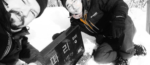
The timely descent from Dosolbong and picturesque ascent to Ddalibong found us at our next goal around 11. I say the ridge walk on the way over was picturesque because along the way we could catch regular glimpses of HL/JN-/JB-/GN-001 and JB-003 as well as a precariously positioned tree, growing atop a cubically shaped boulder and jutting out horizontally into space (the tree, that is). I had to stop and take it in from all angles.
따리봉해로 도솔봉에서 하산 빨리 했고 능선따라가면서 양쪽으로 보면 완전 멋있는 배경들 볼수있었어요…북쪽을 보면서 지리산 종주를 전제 있었다: 노고단에서 반야봉과 토끼봉 쭈~욱 천왕봉까지 깨끗하게 새로운눈에서 나왔어요! 그리고 중길에서 큰 사각형바위에서 가로의 나무가 기울고 있었어요! 정말 난 모든 방향에서 확인 해야댔어요! 암튼–따리봉에 11시정도에 도착했어요.
Whereas Dosolbong we had all to ourselves, Ddalibong was definitely bustling–especially since lunchtime was approaching, the smell of ramen was in the air! Potentially sacrificing our signal just a wee bit (that portion which would be projected north, that is) we decided to set up on the wooden porch for the convenience of the level/vertical posts with which to use to set up the antenna. Just to the north of this porch and the summit marker was some earth/rock rising up about 3m…thought it wouldn’t matter much, but it did make a difference in the end, as was evidenced in signal reports from Jeonbuk.
우리는 도솔봉 스슬로 지낼수 있었는데 따리봉에서 인간수 더 많아서 점심시간되니까 라면향이 났어요. 정상에서 남쪽방향에서 나무로만든 베란다가 있었어서 저기서 안테나 편리하게 설치 할수 있어서 운용위치 선택했음…그렇지만 바로북쪽에 (마커표나서 땅 아마 3미터 오라왔어 우리 전북 신호가 좀 먹었어요.
Taking into account, reduced signal (just a little), lunchtime lull as well as some snacking of our own (when will I learn not to bring my own food up mountains??? We got all kinds of stuff: more tangerines (I already brought a dozen with me), a huge sweet potato (why not?), etc. Really–the day I plan a through-hike of the country, if I play my cards right, I could really travel light!) this activation took a bit longer to complete. Though, it did work. Then down again, onwards then upwards to the third and final summit, Baekunsan.
모든것을 개산하면: 줄림 신호를 (조금만), 점심시간 주파수의 진정을 그리고 자기간식하기를 (정말–난 생각 잘 하면 밥없음 백두대간 전체 가능해요…오늘은 뭐…감귤 (더!), 왕고구마, 초코, 등) 때문에 이 2번째 운용은 더 오래 걸였는데 합격 됐어요! 그다음: 하산하고 또는 오늘의 3번째와 마지막의 꼭대기 백운산 오라갑니다!
At the bottom of the dip in this last section of ridge lies another forest road, the same which I ascended with DS4GKA back in 2011, and I had half the mind to descend via this route, especially if it were snowy (which it was) having brought a sled to allow the going to go a bit faster…however with our route choices this time around, it was not to be. Either way, it proved an opportune time to crack open and share a nice dark Czech doppelbock that ZLH had lugged up and down the first two summits~!
아래쪽에 있는 고개에서 임도가 하나도 있어요: 2011년에 DS4GKA OM님이랑 오랐어요…이번에 설매를 거의 가지고 왔어요–그대로 하산 정말 빨리 할수 있는생각 했지만 이번엔 산길선택 떼문에 못 했어요. 아무튼 거기서 ZLH의 배낭에 나온 체코 또펠보크 흙맥주를 나누서 조금동안 쉬었어요!
The final ascent on up to Baekunsan was definitely the longest, which is why we saved it for last, to not burn out before hitting the other two peaks! With plenty of chances to take a rest, the view back to today’s previous peaks was quite nice!
우리의 마지막 등반 확실히 오늘의 제일 길은 것, 그래서 마지막으로 예정했어요. 휴개위치들이 많아서 우리 벌써 지난꼭대기의 배경을 자주 볼 수 있었어요!
Baekunsan consistently gives good views of Jirisan, probably since it’s to the south thus the lighting is better…always from other summits such as Deogyusan, etc to the north, most of the time all we get is a silhouette in the distance.
백운산에서 지리산의 보기를 항상 잘 나와요…아마 이 방향에서 빛은 항상 더 좋으니까요. 다른 북쪽있는산에서 (덕유산처럼) 지라산에 보면 그림자 그림만 나와요.
Endlich! Finally arriving at Baekunsan’s summit, snap off a couple photos then set up….only finding a good supporting signpost where I activated in 2011, we weren’t quite satisfied with the signals (or lack of people responding leading to perceived bad sigs), so moved up from the south face up to the crest of the summit, taking turns to hold up the antenna while the other was activating, all to ensure transmission of the best signal possible.
마침내 백운산정상에서 도착하고 사진 몇장을 찍! 찍! 찍고 설치 하고…아이…저번 2011년에 사용한 마커표나무대밖에 좋은때 못찾았지만 (거기서 신호가 그렇게 좋지않았음) 꼭대기바위바로옆으로 이동했고 한명은 교신하면서 다른사람은 폴대를 잡고 제일 좋은 신호 송신 했어요.
However, still it seemed to be difficult, to the point which I was fishing for contacts on the local Echolink node (not successful, but an OM in Pohang was eager to chat) as well as 6K5CSL over in Sacheon (by Jinju) was also trying to rile up chasers for us!
아직도 4국까지 힘들어서 에코링크에서 낚시를 해보고 사천엔 6K5CSL은 우리위에 씨큐 불고 있었어요!
In the end, we did manage to squeak by, wrapping up the whole affair by 16:30, not without observing a helicopter rescue just to the east of where we were. Always some excitement on top of the world!
마지막으로 운용 되였어요–16시반까지 완료, 바로 동쪽엔 헬기구조도 봤어요! 세상위에 우린 심심하지 않아요!
Korea QRP Club outing
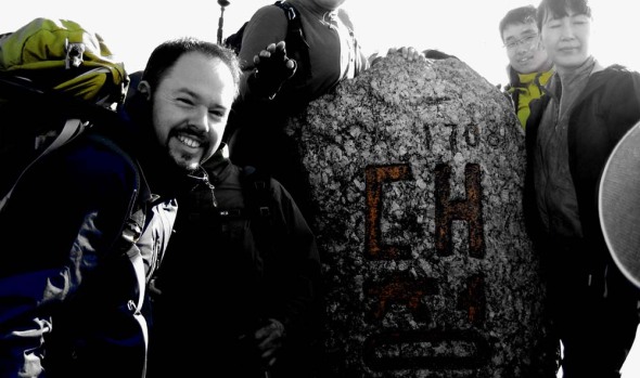
Activating HL/GW-001 설악산 on June 5, 2011 was an endeavor that took about 25 hours. HL1KKC and his Korea QRP club arranged this trip, last time having done it in 2007. After having trucked up to Seoul and meeting 6K5ZLH (who also had to find his way up to the Special City), grilling and eating some porcine flesh on the sidewalk with N5ATY, we took the subway to the other end of Seoul to meet the others at 11 PM and hop on their bus that they had out for the excursion. It was well arranged, we arrived and literally thirty seconds later it was like “here’s your beer, the meat’s on the bus, hop on and grab a seat.”
You’ll note that the departure time was quite late–that being because our hike started quite early: 3 AM. We arrived at the Hangyeryeong Rest Area sometime around 2 o’clock to eat and get ready (this wasn’t our point of departure, rather our final arrival point later on that day). The place was crawling. No place to park, the food stands open and running, the bathrooms steaming, traffic not flowing, really. It was hopping more than those huge pullovers next to eight lanes of traffic at the same time!
We got back into the bus and started on our descent to O-saek Yaksu (it is lower) twisting and curving along the road until hitting this other “rest area” though not the area proper. There was a good quantity of people milling about, and even though it wasn’t quite three o’clock yet, the trail was open and one could just barely see the lights bobbing up the hill in the trees.
The way up was actually quite normal, just a bit longer (it is a trot up to the top, there!), we took a couple of short breaks on the way up, and upon arriving just below the summit at maybe a quarter to seven, out of the wind and waiting for the rest of the group, HL1WOU already already had a slim jim thrown up into a tree and was making 59 QSOs to Seoul, 140km away with his HT. We had to wait out of the wind, because although we may had been hot at the bottom it was actually quite chilly (very chilly?) up on top!
At about ten after seven, we had everybody amassed together again, and set out to brave the crowd on the summit. This is seven AM, not New Year’s morning, and there’s a crowd. On top of Seoraksan, Daecheongbong, there are actually two markers. For each marker there are two lines: one for the photographers, one for the photographees, naturally the two lines advance at the same rate as you have things pre-arranged with your group. Hence the two summit shots above, and not necessarily with everybody coordinated together!
I chose “the sunny side” of the summit to set up initially, it was in fact sunnier, and a bit less breezy. I actually activated from that position, making my first four contacts of the day, including with Mr. SHC who was starting out on his way to that very same summit from a different point down below!
After these first QSOs, we decided to move more over to the westerly side of the summit, finding a rock from which to operate behind, out of the wind, a decent location for the antenna, also.
Much of activation was conducted using five watts, CQing at higher levels to break through people’s squelch at home–however, for those closer contacts that were more tucked into the hills the going was tough even at fifty watts (though almost 300km away to Iksan on five watts brought me a 55 report–that’s with no GP, no Yagi, just a two segment mobile whip!)…
6K5ZLH and I operated on and off until about half past eleven local time to both activate. We were graced by some visits, first DS1RZP, then DS2SHC. We then packed up and headed down to the shelter where HL1KKC and his crew were operating, getting lunch ready, eating or napping in the sun. While down there and catching up on the news, we found out that evidently a hiker who also took to the trail that morning didn’t make it up, having a heart attack on the trail (there are some warning signs at the more popular high peaks outlining the dangers, which are more present at the “must see” destinations that see a much broad range of skill sets attempting the trail). Actually, later on in the afternoon during the descent we saw another rescue helicopter out looking for somebody–not sure it’s increased risk or simply an increased quantity that shows the normal risks that exist at any time.
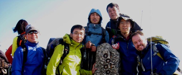
At one o’clock, after having taken the group shot below, we started our descent, rather, what I thought was to be our descent. Hangyeryeong is a few hundred meters higher up than Osaekyaksu, but the path there is still a good distance. There were a few times when we passed markers indicating our elevation was “currently” 1300 meters–wait, we’re supposed to be coming down from 1700 to 800, when’s it gonna happen? We had quite a few re-ascents right up until the end (I can’t say it wasn’t an interesting trail…some of the views were quite spectacular), then four hundred meters of drop all in the last (less than) two kilometers!
Though ZLH had so graciously offered to truck the 12AH SLAB both up and down, with the 857 and other equipment I was still eager to lose that heavy load, hence my lack of excitement when the reality of the “downhill” came about 😉
At the bottom after a nice cool head rinse, tea and re-hydration spirits were much higher again.
Eventually, everyone made it down (gravity happens) and the fully loaded bus started moving west, only to pause a while later once we got out of the mountains for the obligatory 닭갈비.
As for the rest of the trip, I don’t think much was remembered by anyone, as everybody was sleeping until we got to Seoul, dropped off by Seoul Station at half past midnight…such a late arrival wouldn’t even be enough to stop me from even a mini-activation the next day…
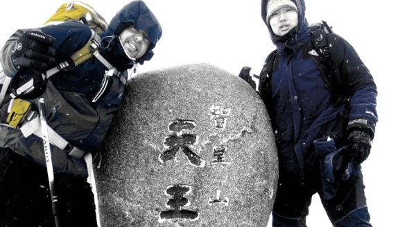
The big one–Jirisan Cheonwangbong
Much to report and oodles of video footage for this winter weekend outing to 지리산 천왕봉 with DS3MBB, DS3OCN, DS3OCO & 6K5ZLH. Stay tuned for more, but at least the summit shot and log for now!
15km for 20 points!
All to breach the 100 point barrier–and well before Christmas! As the “mini-ascent” to JB-007 삿갓봉 only added 2.4 km to the total of my walk and I had just the right amount of daylight left to get it done, it was quite the deal.

It was important to get out before dark as it this was in Deogyusan National Park, and they don’t like folks doing night hikes (liability, etc) so even though the trail was not very rough at all and I had adequate lighting I’d have to deal with closed gates and such to get out, or sleep at the shelter (which I happened to pass thrice total due to my routing up via the Sakatgol valley/pass trail). If one chose to sleep at one of the many shelters provided, it would be quite easy to knock off 40 points in one weekend outing along the Deogyusan ridge, possibly even more–the facilities are cheap, manned, with limited food as well as other services available.
I made the requisite 4 contacts, took the obligatory summit shot, and quickly scuttled back down–it was 4 PM already and I had roughty 1.5 hours of descent from there… 3 out of those 4 QSOs were actually S2S to other hikers, up to Songnisan, Gayasan, and another mountain in Geochang, nearby. Unfortunately, 6K5ASG/p Gyeong-il at Gayasan was already an hour into his descent when we made contact, he was at 서성재 pass, well out of the AZ, but maybe 6K5CGB/p Ahn-seup in Geochang might provide me with some chaser points on this second summit (S2S pointage w/CB-014 was already claimed a couple of hours ago from Muryuongsan, and 6K2GZJ/p Tae-in was also just starting his descent.). We’ll see once I get more details.
All in all, successful, although I had to leave immediately after activation…
When I returned to the village at the bottom of the mountain, the field of cabbage I had passed by on the way up now only evidenced massacre.
김장 complete.
73.
Merci Fabi le fif pour le cigare!
20101113 JB-005

Closing in on the gap…it’s been a few weeks since my last SOTA expedition, and two weeks since my last hike(s) (non-SOTA) so I was itching to get out.
Now, as it’s “fire season” (nice and dry with lots of tinder laying about the countryside) many smaller “private” mountains are off-limits for the next few weeks, so one of my better options was to hit a national park, which remains open (and usually has some kind of surveillance system for fires and other such emergencies, also) a bit longer (I believe Deogyusan Nat’l Park‘ll be closed or at least restricted in some areas from November 15th to December 15th).
So, looking at the maps, trails, and elevation changes, I figured I could possibly make this outing really count (especially since it’s a little over an hour, one way, plus five bucks in tolls, to get to the trail head), and hit two different summits, time (sunshine) permitting, hitting the closest (Sakatbong) then Muryongsan, if possible. In the end, upon seeing what my real trail times were, I decided to hit Muryongsan first as it was the one that was “farther out” and slightly higher.
Getting started was a bit rough here, as I didn’t want to lug the big yagi all the way up the hill….a bit of a mistake. It appeared as if nobody could hear my signal. I did some tests between the two HTs and the different duckies and turns out the stock was better than my Diamond….must be something wrong there…and that the VR-6 was more sensitive than the VX-170 by one or two S points. After a few big groups stopped on the summit, ate lunch and whatnot, I finally started to get some contacts, must’ve been the timing or something… Had some so-so signal reports, however when I started making summit-to-summit contacts, the reports skyrocketed–so, my conclusion is the people on the ground with their systems in the Nebel maybe needed some adjustment.
As I was packing up, I left a little Geeocashee treat for future travellers passing through…
To top off the list of QSOs from this summit, before heading down and over to JB-007 Sakatbong, I heard 6K2GZJ/p starting to call CQ from CB-014 Songnisan. Though having heard of SOTA, he was still new to the business, so I gave him some pointers, though I was pleased to hear his strong (5W, 59++) signal over the 85 or so kilometers that separated us. In the meantime, I walked away with 10 chaser points 😉

There’s also a spring located right below the Sakatgol Shelter, at 35.79059°N & 127.70509°E to fill up at.


And…for you GIS-heads out there, trig point trivia!
삼각점 literally means “triangle point” in Korean
위도 = latitude (remember that 위 means “up”)
Likewise for weather, time and location, 도 = degrees, 분 = minutes and 초 = seconds.
높이 is a reference to height, whereas 해발 is height above sea level (as is indicated by 해, sea).
GN-007 鷄冠峰 on 20101017
Alas, I’m back out in the wild again after a couple weeks’ worth repos–I went down to Hamyang to check out this less frequented ten pointer called Gyegwansan. This area is quite convenient for me, as just recently (at the end of 2007) this new section of highway 20 was opened–it goes right from Iksan IC (technically, Iksan JC, 2 km south of Iksan IC on the 25) down to the 35 at Jangsu, in the heart of the mountains, at the bottom of Deogyusan National Park, and likewise this area makes good apple country.
–utz! Not so quick, there! For a few reasons:
Finding the trail head wasn’t an easy task, in fact, going up, I didn’t find it. I was half following a deer track (with some recent prints), some gullies, and found an older marked path (white paint on trees) which may be what was on my older map on the gps…after about 200m of ascent (up to about 700/800m) I finally found “the real” trail, or at least, that which is most beaten and ribboned.
The other trail was passable, though slightly overgrown, and more difficult in some places (even though it ran 50-100m down the hill parallel to the beaten path). Maybe two minutes after getting on this main path, did I come across an older couple out looking for 산채, wild mountain veggies. They asked me why I was going up so early (it was already an hour after sunrise)…ahem, I almost didn’t make it down to the car before sunset!
As of April 7, 2009, Hamyang-gun (county) announces the change of Goaegwansan 괘관산(掛冠山) to Daebongsan 대봉산(大鳳山), additionally of Cheonhwangbong 천황봉(天皇峰) to Cheonwangbong 천왕봉(天王峰), and naming of the western peak as Gyegwanbong 계관봉(鷄冠峰).
This is to reflect locally familiar names to this mountain and its peaks, as well as nomenclature of Korean origins, whereas Goaegwansan and Cheonhwangbong were assigned during Japanese colonial rule, Cheonhwang 천황 giving hommage to the Japanese Emperor, as opposed to Cheonwang 천왕 to the Korean. Gyegwanbong refers to the shape of the mountain’s profile which resembles a chicken’s crop.
국토지리정보원 제2009-239호
South Deogyu on 20100923

JB-004, 남덕유산. One and a half hours on the road. No traffic. Three hours up. Who knows how many stairs. One thousand five hundred and seven meters. Six hours on the summit. A few odd looks. Five Watts. Six Elements. Fourteen complete QSOs. A number of partial QSOs. A few (two confirmed) S2S QSOs. Less than two hours down. Two hours back home on the road. One load of laundry. A night of sleep.
지리산 만복대 on 20100921
I can finally say “I’ve gone to Jirisan” since I couldn’t really explain why I hadn’t been there yet at least once during my (to date) three year tenure in Korea. I guess I can be comforted by the fact that my hiking companion (only a year or two my junior) had never in her life been to 지리산, and her hometown, Namwon, is at the foot of this hill…ahem.
Also, Manbokdae (JB-006) has already once been activated, earlier this summer, by DS1SED, also on VHF. A nice high summit like this lends itself to VHF activations because of the nice, long distances that are easily attainable on low power. The majority of this activation I was operating on five watts, occasionally upping it to 20W for those tougher contacts and calling CQ.
Though I have to say, I didn’t have to call much on this activation at all–as a matter of fact, the instant I had turned on the rig after setting everything up, guess whose voice I hear? Wan-seok 6K5ZLH! I’ve been trying to log a contact with him during the last two months, not once being successful (a matter of timing and weather, mostly). He lives “on the other side of the hill” but from his city of Gumi, is surrounded by high-pointage peaks. So, I broke into his contact with DS5WEP and subsequently logged my first two contacts.
After these initial two contacts, and the acquisition of ten chaser points grâce à 6K5ZLH who happened to be on Deogyusan‘s main peak Hyangjeokbong JB-002, the regulars were already in line, third up: DS4QBE, followed by DS1SED/4.
As part of the National Parks’ Special Protection Zone program to “give some areas a rest” the particular section we ventured through was “closed.” Luckily enough, it was only the area and the actual trail going through was not off limits, as can happen in other areas and parks. That kind of situation (such is as seen at CN-003 Gyeryongsan) can disable any access to a summit (usually the highest and most popular) and can last for a [very] long time. There are periods with expiry dates on the list that go as far as 2028…
