Another 74 in 24
You know you’re in a farming town when you’re out in the street at 5:30 am and you see more people out than you’d see at lunchtime…folks milling about, rambling down the street on their tractors, etc. Sangju decidedly has two crowds: the locals and everybody else (tourists and whatnot). I wouldn’t expect to see the others out of doors until after nine. In fact, my little tourista 😉 wasn’t up until ten, let alone out the door.
Anyways, I left the “Big Pine Motel” (sounds really redneck, eh? literally : 큰솔장) early to get a quick [unplanned] activation in at HL/GN-074 금산. The intention was to do this yesterday, but due to the holiday and everybody who was out, I couldn’t even get to the main parking lot, or even the ticket booth! Traffic jam at Geumsan! We just turned around. This morning, cruising up the road, I had the place all to myself, saw very few souls, and not until reaching the upper parking lot. That’s in fact the reason why this was set aside for a quickie not to get in the way of things too much: there’s a nice road leading up to a secondary parking lot at about 600m ASL.

Now, why a mountain would have a lot that high up is beyond me, but the Bori-am Hermitage there is quite the popular destination. I know, the engineer who planned the place with paved roads and parking lots should be shot as he clearly couldn’t bother to look up hermitage in the dictionary. The point is, it is still quite convenient to be able to get up that far and walk the last kilometer/ascend the last 100m if one is pressed for time. Moreover, I’m sure if one’s in the loop with one of the monks, you could probably get past the barriers and even closer.
Seeing the sign extolling the dangers of lightning (first time I’ve seen one of them around here) reminded me of our return to the warmer months, bringing with it mosquitos, spiderwebs and thunder bolts to chase you off of summits and foil activation plans…
Around 6:30 I arrive [very comfortably] at the summit, Mangdae, with a nice stone tower built to hold signal fires. Fun, as I was there to do some myself. Even though the weather wasn’t as clear as it was yesterday, I could see quite well down to Sangju, as well as to HL/GN-274 만운산 where yesterday’s activation was (view above).
 I figured that since it was so early, VHF wouldn’t be my best bet to get contacts, so proceeded to set up the buddistick for 40m. Ironically enough, all of my QSOs, HF or otherwise, were domestic, starting off with DS1SED/4, we went through some tests going up to 100W and down to 5W where he could still copy me quite well though might night get many takers as I called CQ. I made one closer contact to Daegu at a full 100W as he had trouble copying me, then the rest of those I talked with at farther distances I had the luxury of going at only 20W with good reports all around.
Once eight o’clock rolled around and the summit activated on 7 MHz I decided to turn to VHF for the last portion of the activation before heading out, as the people were increasing in number and just maybe a smaller antenna would be less weird (who am I kidding, right?). I started calling CQ and had a steady stream of takers near and far (even YOP on one of his routes!) at varying power levels including DS4GQZ on the rooftop of his office with his HT in Suncheon and over to Busan, also.
During the course of the VHF portion of the activation I met one inactive ham on the summit, though hopefully he won’t be inactive for long! After packing up, I took a detour to check out the hermitage, then continue on my way out. The ride down was uneventful (brakes still good, low gear descent charged my SLAB 😉 but the traffic was already backed up at the ticket booth a good half mile.
Back at the Big Pine Motel I had my second cold shower of the stay (I had already mentioned this to the owner last night, it still wasn’t fixed/turned on/joke finished/whatever this morning but I stink/stank/stunk). Afterwards it wasn’t the first time I looked up the hill asking myself why we didn’t try overnighting at the 찜질방 in Sangju. Evidently we weren’t the only ones to be disappointed with Sangju’s Silver Beach. At least we saw goats, though! Also had an assemblage of sashimi for lunch up the road!
Riding the South Sea
Children’s Day 2011 makes Friday into a sandwich day, then Buddha’s Birthday the following Tuesday has the same result on Monday. Therefore, it wasn’t completely crazy to take advantage of that, at least on one end or the other (if we took both off I’m not sure we could handle six days straight with no class!).
So, Thursday at 7am saw us riding down route 20 towards Jangsu to continue onwards to Jinju and finally Namhae Island (IOTA AS-081). We were originally thinking of Geoje Island then ferrying it over towards Busan for Sunday’s ARDF, but then remembered about the German Village we wanted to see, researched where it was, and changed itinerary.
A word about said Deutsches Dorf, don’t bother. Yes, there are some pretty residences, but you won’t see any Germans. Only Koreans. The signage is in English/Korean, the café doesn’t even have a streudel on the menu, let alone any coffee specialties besides a sweet potato latte (which is more typisch koreanisch than anything else) and there aren’t any restaurants. I was told there was a food court inside the plant-art park (admission fee required), but heard the best I could expect would be a 돈까쓰. Insulting.
We then left the traffic jam back there at the 독일마을 for some nice seashore cruising ascending and descending the cliffs, finally stopping at 마늘 나라 garlic museum, then lunch further on, then turning back towards Sangju “Silver” Beach to find lodging and have fun. I took a spin around the beach on an underpowered ATV (like riding a chainsaw with wheels) then we were both bored, so gee, there’s a mountain nearby, it’s short, and the weather’s nice. Can we squeeze that in before dinner? It’ll be short….oh, ok.
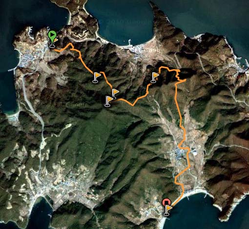
The village of Mijo where GN-274 Mangunsan is located is only 4km away from Sangju, so it took only 10 minutes to get there, we found a road going up the hill, but didn’t go up due to the signage (military? something?) but the school janitor at the gate said go up anyway. Or waved to go up, or some gesture. Wasn’t much of a talker. So, we turned around to hit the village to get some cold drinks (thanks Zoom, you’re a good friend!) and ask there. Same response, just go on up. We go up, get to a space with the building, some basketball courts, barbed wire, etc. The young guy on duty shouts down something, then an older guy is coming out on his way home, says yeah, there’s a path off to the side I can go on, but preferring not to have the audience I ask about others, and well yes, there are, further down (by the school) as well as the other side of the hill, etc. With this info, we head back down following him and park at that lower trail head (see wikiloc map below).
It’s a short hill and it is really a short walk getting to the top, but it’s got some nice views to the surrounding coasts and islands (when it’s clear). Immediately upon arrival at the summit, I hear a Japanese station calling CQ. Now, this is right when I get up on top, still carrying backpack, looking for a site to set up, on the HT at 55. I call back–he says I’m 59. This is still from the HT with only the duckie antenna. The station is 8J400MK, a special event station 460 km away celebrating the 400th anniversary of the completion of construction of Matsue Castle in the Shimane Prefecture, Japan. What a way to start out the activation–2m DX!
From there I try calling some CQ on the HT with no results so go about setting up for HF operations, set up the buddistick for 40m and go at it there, contacting only one portable station. 20m on the other hand was a bit more happening, and logged northern Russia and south-eastern China. All the while, I hear somebody on another mountain, but can’t seem to break in with the HT. Now I set up the FT-857 for 2m with DS4QBE’s 2-section whip, and he gets me perfectly fine, but he’s at the end of his battery, so the QSO was a bit one way and on the rough side with DS4GKA/p on HL/JN-332 Museonsan in Yeosu.
After one last 2m QSO with a fellow on his way to Samjeompo (also on Namhae Island), I quickly packed up to head back down so we could go for dinner. The activation wasn’t as short as it should’ve been, but it was still as fun and just as interesting. This last shot (below) is of Mijo Village from the trail head.
ARDF on HL/GN-292 Daebongsan

I had gotten some news from Peter DK4YO about some fox hunting happening somewhere “down south.” This being something I’ve heard about many times, the stars hadn’t aligned until now for me to give ARDF a try.
It happened to be that the 거제도 지부, the Geoje Island KARL branch was hosting the March competition at the northern end of the island, where HL/GN-292 大峰山 is located.
So, after a few last minute phone calls around I hooked up with HL4GWB and I joined his carpool leaving Jeonju the next morning at 5 am. Three hours on the road having passed we stopped when we got on the island for a breakfast of 잔치국밥, which basically resembled a 육개장.
Just as we were finishing our meals up, a bus with a load of Seoulites also going to the competition pulled up for breakfast. Among their ranks was HL1OLA who I had a QSO with just a few weeks before from Bulamsan!
Upon arrival, we signed in and got our jerseys for the race. I got a quick crash course in ARDF before we were bussed off to the other side of the mountain where the start point was.
My group’s start time was at 11 o’clock, so as everybody was waiting around someone started whacking a volleyball about, which provided good warm up. In the middle of all this, DS3MBB & OCO pull up–I guess they had taken a wrong turn somewhere along the way down from Daejeon.
Off we went–getting off into the course, then splitting up after a few hundred meters. Some competitors had to seek out certain foxes of the five, me, I could go for any three that I could find since it was my first time. My main goal was to get out there and see what was beeping. At first I started following five but then saw that fox #1 was much stronger. In quick time I found fox #1 (as well as many others, from the group let loose behind me five minutes after ;( heheh!
At that point, it wasn’t possible to continue, so we had to backtrack a few hundred meters then I chose to go up the ridge, towards the summit. Going towards five I got distracted and took a tour of the summit of HL/GN-292. I descended again and got back to business, finding #5 quite a ways off farther than I expected.

Then comes the part that ate no less than 50% of my alloted time: going for beacon #4 which seemed to be close by, I went eastward in its direction. Coming to one of the main roads, I decided to head up to a pass where there should have been a trail (according to the map, and GPS as well). Well, there should’ve been a trail up to the pass, also, but I ended up engaged in a good 20 minute scramble to get up there to find a small track, and my nice strong signal for number 4 much diminished.
However, number 2 popped up on the radar quite strongly…more importantly it was on the way to the finish which is important as even if you get your three foxes if you’re over time you get disqualified. I started booking that way with only forty minutes remaining. At the bottom of the hill the fox still hadn’t turned up yet, ran into DS3OCO and continued (he wasn’t as pressed as I). I got extremely close to #2 but with less than ten minutes remaining and a rocky beach to run along couldn’t waste any time.
I managed to get to the finish line with about five minutes to spare and only two foxes found, despite all this I still finished first among the first timers participating that day.
The big one–Jirisan Cheonwangbong

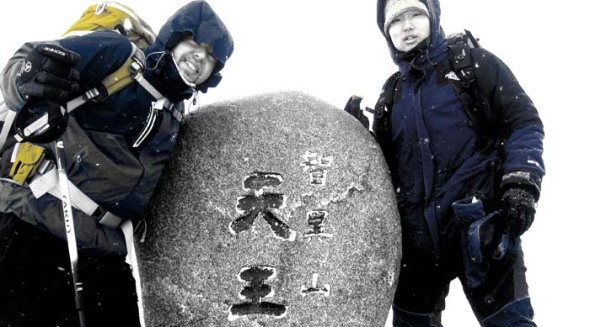
Much to report and oodles of video footage for this winter weekend outing to 지리산 천왕봉 with DS3MBB, DS3OCN, DS3OCO & 6K5ZLH. Stay tuned for more, but at least the summit shot and log for now!
GN-007 鷄冠峰 on 20101017
Alas, I’m back out in the wild again after a couple weeks’ worth repos–I went down to Hamyang to check out this less frequented ten pointer called Gyegwansan. This area is quite convenient for me, as just recently (at the end of 2007) this new section of highway 20 was opened–it goes right from Iksan IC (technically, Iksan JC, 2 km south of Iksan IC on the 25) down to the 35 at Jangsu, in the heart of the mountains, at the bottom of Deogyusan National Park, and likewise this area makes good apple country.
–utz! Not so quick, there! For a few reasons:
Finding the trail head wasn’t an easy task, in fact, going up, I didn’t find it. I was half following a deer track (with some recent prints), some gullies, and found an older marked path (white paint on trees) which may be what was on my older map on the gps…after about 200m of ascent (up to about 700/800m) I finally found “the real” trail, or at least, that which is most beaten and ribboned.
The other trail was passable, though slightly overgrown, and more difficult in some places (even though it ran 50-100m down the hill parallel to the beaten path). Maybe two minutes after getting on this main path, did I come across an older couple out looking for 산채, wild mountain veggies. They asked me why I was going up so early (it was already an hour after sunrise)…ahem, I almost didn’t make it down to the car before sunset!
As of April 7, 2009, Hamyang-gun (county) announces the change of Goaegwansan 괘관산(掛冠山) to Daebongsan 대봉산(大鳳山), additionally of Cheonhwangbong 천황봉(天皇峰) to Cheonwangbong 천왕봉(天王峰), and naming of the western peak as Gyegwanbong 계관봉(鷄冠峰).
This is to reflect locally familiar names to this mountain and its peaks, as well as nomenclature of Korean origins, whereas Goaegwansan and Cheonhwangbong were assigned during Japanese colonial rule, Cheonhwang 천황 giving hommage to the Japanese Emperor, as opposed to Cheonwang 천왕 to the Korean. Gyegwanbong refers to the shape of the mountain’s profile which resembles a chicken’s crop.
국토지리정보원 제2009-239호


