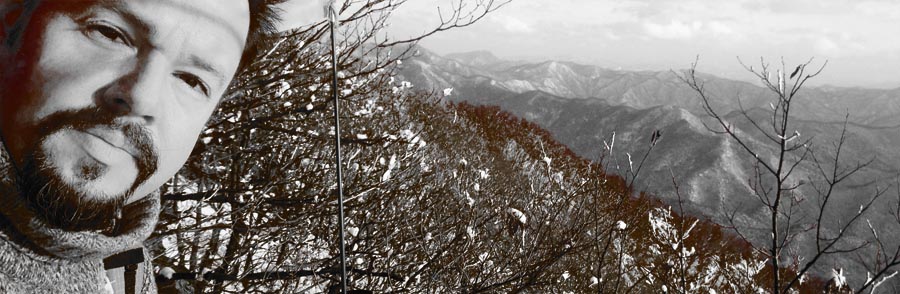
Tuesday Gyeonggaksan


Always love it how people start freaking out when it starts snowing, but it seems to be when it’s too late to actually take some action (despite a bit of snow now and then, haven’t seen a snow day around here…I figure it’s a byproduct of schools conveniently being located within walking distance–for the students, at least). Just the other day my co-teacher came rushing into the classroom at 4:22 PM, to tell me that I could leave early due to the inclement weather. Really. Backstory: my last class at that school finishes at 12:20 and I have free time all afternoon until the sun sets and I am released 4:30 PM when I may go join the hordes of other mindless labourers who all due to any lack of coordination must congest the roads in unison to ensure a punishable return home.
눈오기 시작하면 여기있는 분들 행동 이상하진다–해마다 겨울 오겠잖아요…왜 준비를 안 해요? 눈이 많이오면 학교이나 다른 행사 취소한경유 아직 못 봤어요. 다른 날에 나의 팀강사는 오후 4시22분에 교실에 빨리 들러왔어요: “쌤! 날씨가 나빠져서 오늘은 우린 일찍 퇴근 할 수 있어요!” 정말. 있잖아요…나의 마지막 수업을 12시20분에 끝나고 4시반까지 오후동안 계속 자유시간 있어요. 진짜?
Focus people! Logic dictates that increased levels of sublimated precipitation would be found to my south thus that is the direction of travel which I must pursue. It could also be the fact that it is December sixteenth and all of the trails which had been banned from entry during the last two months would finally be open again–with the gates open, I whole-heartedly rushed into the heart of the storm, splashing nimrods cruising at 20km in their all-season tired non-lit white SUVs with slush as I exerted my full on Pride™ power: 1300cc and 50W on 2m. Three hundred meters up at the Fire Pass, I pulled over and parked at my usual spot.
집중! 물론 남쪽에 더추우면 날씨더 나쁘면 난 반드시 그 방향으로 이동 해야돼요. 혹시도 오늘은 12월 16일이니까 거의 2개월동안 통제되는 산책길들 이젠 열린다–가슴 기쁘고 폭풍으로 들러가서 여름타이어신은 저속 SUV를 추월하고 프라이드™ 파워 300미터 불재까지 편안하게 도착해서 보통위치에서 주차했어요. 스노우타이어도 도워 줬어요 ㅎ

Breezy and snowy would be a fitting description of the conditions as I followed a single pair of footsteps going up the hill…until I reached the top of the western ridge. Let’s just say there weren’t any paragliders today catching some ridge lift… Had I not known the trail by heart, that there was shelter up on top (and have someone else ahead of me somewhere uphill) I’d seriously question why I was up there. Eh, the answer is simple: points is points. I was fully warmed up but couldn’t take off my windbreaker because it was so blustery! There were some drifts already formed, but it wasn’t whiteout conditions or anything, either. Besides, there aren’t any alternative routes on this trail, it’s straight or straight down.
산행을 출발 해서 발자국 1개 딸라서 날씨가 통퐁이 되고 눈이 계속 내려오고 있었어요…서쪽의 능선까지. 거기서 바람 많이 불렀어요! 오늘 능선 리프트 타는 파라그라이더 볼 수 없겠다~ 정말, 이 산길을 안 외우고 위에 대피가 없으면 (그리고 앞에서 어디서 한분이 있고) 정신을 확인 해야겠어요. 암튼 점수는 점수에요. 몸이 참 따뜻했는데 바람 (태풍?) 때문에 바람막이 바찔 수 없었어요! 눈더미가 여기 저기 있었는데 아직도 잘 볼 수 있고 그길에서 다른 길 선택이 없어요.
Upon finally reaching the peak with the fire tower, I left the prints to continue on their merry little way without me (doing the loop course?) while I set up the 5s antenna and retreated from the wind to activate. The last few activations haven’t been that difficult to achieve, QSO rate wise–well today was going to turn that around: it took forever and a half to obtain four contacts, all basically local, with excellent signals.
산불감시초소탑에서 발자는 날없이 계속걸려서 (둘레 코스한다?) 5단지피 설치하고 탑속으로 가서 운용을 했어요. 요즘 저번 몇 운용이 합격하기 그렇게 힘들지않지만 오늘은 진짜 어려워서 QSO 4건밖에 못 잡아서 모두가 그냥 강한 지방 신호들 됐어요.
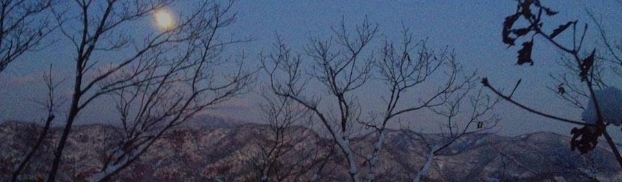
The descent sloughing through the drifts in the dark was quite pleasant, only catching a few new sets of tracks, some rabbit, some deer, nothing bigger this time around, reaching the car at just a little after seven o’clock. The roads weren’t so bad on the way back that I did arrive at diner’s club on time–what was interesting was that south of the Mangyeong River had the worst of the road conditions but on the other side things were very clear (until getting downtown again, that’s another story).
18시10분에 정리하고 우리 우더운 눈길로 하산을 행복했어요–토끼와 사슴보다 이번엔 더큰 발자를 (인간제외) 보지 않고 19시 좀넘어서 자동차에 도착 했어요. 길거리 월성봉갈때보다 좀 더 좋아서 완주군과 김제에 좀 미끄럽지만 만경강을 지나서 갑자기 도로는 깨끗했어요! 와! 시내까지…ㅎㅎ 그렇지만 화요일마다 만남 다이너스 클럽에 늦게 도착 하지 않았어요!
On top of Jeonnam!

Every direction you turn these days, there’s a wedding…’tis the season! Gotta get’em all done before next [lunar] month–or else…
요즘 어디든지보면 결혼식이 있다…윤달전 빨리 빨리 해야지!
Yesterday, Se-heui tied the knot, so Saturday was out of the picture, thus Sunday really had to count. Problem these days is that it’s technically still fire season, and so many of the possible “double activations” have one of the two summits cordonned off. Luckily enough, down south, just to the east of Suncheon, a nice trio of summits was 100% open: HL/JN–005 Dosolbong, HL/JN-004 Ddalibong and HL/JN-002 Baekunsan. I’ve been to this Baekunsan before, back in December of 2011 with DS4GKA (based in Yeosu), but only that one summit, not visiting/activating the other two.
어제 세희는 결혼 해서 토요일오후동안 거기서 있어 산으로 못 가서 일요일에 가면 진짜 잘 해야 됐어요! 산불기간 아직 못지내서 너무 많은 “더블 운용” 산에 두개중에 하나는 통제이다. 그렇지만 남쪽에, 순천보다 동쪽에 3까지 같이 산 다 진입가능 해요: HL/JN-005 도솔봉, HL/JN-004 따리봉과 HL/JN-002 백운산. 예전에 2011년 12월에 그 백운산에 여수의 DS4GKA같이랑 갔은데 그때에 나머진 따리봉과 도솔봉으로 방문 할 수 없었어요.

To make it all work, I left Iksan at 4AM and 6K5ZLH left Daegu even earlier, to converge at the trail head just before dawn. We made sure to travel extremely light, since we’d have to be climbing into three different activation zones today (minimum 150m x 3, but actually more!), starting towards the west to knock off the shorter summits, first, then descend down one of the eastern valleys after Baekunsan.
어떻게 했나? 먼저 새벽 4시에 익산에서 출발 하고 (ZLH OM은 대구에서 더 일찍 출발 했음!) 산입구에서 (어떤 송어회집앞) 일출저네 만났어요. 오늘은 운용지역 3까지 (150미터이상 오라가기 3번) 예정 있었으니까 침을 가볍게 준비 해야됐어요. 먼저 서쪽으로 올라 가고 제일 작은산 맞이고 계속 동쪽으로 이동하고 마지막백운산의 운용을 완료하고 거기서 계곡으로 하산 함.

Having started just as the sun was rising the going was easy, along a gently sloping forest road before that ended and turned into a real trail, zig-zagging through the creek bed. Reaching the ridge line between Ddalibong and Dosolbong then continuing up to Dosolbong we summitted just before nine o’clock, quickly set up and proceeded to activate in good time, despite the earliness (for 2m, it was early, anyway). Seeing as we still had two more mountains to activate, we couldn’t stick around calling CQ all day, so having completed the bare essentials, quickly packed up and moved along.
일출 뽀면서 우린 편안한 임도로 시작 했지만 도로 끝나서 진짜 산길 달랐어요. 능선까지 계곡으로 (개단도 추가있음) 올라 가서 도솔봉정산에 9시전 이쁜 햇볕 만진 남해 보고 있었다. 장비 빠르게 설치하고 운용을 바로 시작 했음–2미터에게 시가이 좀 일찍인데 운용 문제없이 편리하게 끝났어요. 산 2개 남아서 여기서 하루종일 놀 수없어서 교신 많이 못 했어요.

The timely descent from Dosolbong and picturesque ascent to Ddalibong found us at our next goal around 11. I say the ridge walk on the way over was picturesque because along the way we could catch regular glimpses of HL/JN-/JB-/GN-001 and JB-003 as well as a precariously positioned tree, growing atop a cubically shaped boulder and jutting out horizontally into space (the tree, that is). I had to stop and take it in from all angles.
따리봉해로 도솔봉에서 하산 빨리 했고 능선따라가면서 양쪽으로 보면 완전 멋있는 배경들 볼수있었어요…북쪽을 보면서 지리산 종주를 전제 있었다: 노고단에서 반야봉과 토끼봉 쭈~욱 천왕봉까지 깨끗하게 새로운눈에서 나왔어요! 그리고 중길에서 큰 사각형바위에서 가로의 나무가 기울고 있었어요! 정말 난 모든 방향에서 확인 해야댔어요! 암튼–따리봉에 11시정도에 도착했어요.

Whereas Dosolbong we had all to ourselves, Ddalibong was definitely bustling–especially since lunchtime was approaching, the smell of ramen was in the air! Potentially sacrificing our signal just a wee bit (that portion which would be projected north, that is) we decided to set up on the wooden porch for the convenience of the level/vertical posts with which to use to set up the antenna. Just to the north of this porch and the summit marker was some earth/rock rising up about 3m…thought it wouldn’t matter much, but it did make a difference in the end, as was evidenced in signal reports from Jeonbuk.

우리는 도솔봉 스슬로 지낼수 있었는데 따리봉에서 인간수 더 많아서 점심시간되니까 라면향이 났어요. 정상에서 남쪽방향에서 나무로만든 베란다가 있었어서 저기서 안테나 편리하게 설치 할수 있어서 운용위치 선택했음…그렇지만 바로북쪽에 (마커표나서 땅 아마 3미터 오라왔어 우리 전북 신호가 좀 먹었어요.
Taking into account, reduced signal (just a little), lunchtime lull as well as some snacking of our own (when will I learn not to bring my own food up mountains??? We got all kinds of stuff: more tangerines (I already brought a dozen with me), a huge sweet potato (why not?), etc. Really–the day I plan a through-hike of the country, if I play my cards right, I could really travel light!) this activation took a bit longer to complete. Though, it did work. Then down again, onwards then upwards to the third and final summit, Baekunsan.
모든것을 개산하면: 줄림 신호를 (조금만), 점심시간 주파수의 진정을 그리고 자기간식하기를 (정말–난 생각 잘 하면 밥없음 백두대간 전체 가능해요…오늘은 뭐…감귤 (더!), 왕고구마, 초코, 등) 때문에 이 2번째 운용은 더 오래 걸였는데 합격 됐어요! 그다음: 하산하고 또는 오늘의 3번째와 마지막의 꼭대기 백운산 오라갑니다!

At the bottom of the dip in this last section of ridge lies another forest road, the same which I ascended with DS4GKA back in 2011, and I had half the mind to descend via this route, especially if it were snowy (which it was) having brought a sled to allow the going to go a bit faster…however with our route choices this time around, it was not to be. Either way, it proved an opportune time to crack open and share a nice dark Czech doppelbock that ZLH had lugged up and down the first two summits~!
아래쪽에 있는 고개에서 임도가 하나도 있어요: 2011년에 DS4GKA OM님이랑 오랐어요…이번에 설매를 거의 가지고 왔어요–그대로 하산 정말 빨리 할수 있는생각 했지만 이번엔 산길선택 떼문에 못 했어요. 아무튼 거기서 ZLH의 배낭에 나온 체코 또펠보크 흙맥주를 나누서 조금동안 쉬었어요!

The final ascent on up to Baekunsan was definitely the longest, which is why we saved it for last, to not burn out before hitting the other two peaks! With plenty of chances to take a rest, the view back to today’s previous peaks was quite nice!
우리의 마지막 등반 확실히 오늘의 제일 길은 것, 그래서 마지막으로 예정했어요. 휴개위치들이 많아서 우리 벌써 지난꼭대기의 배경을 자주 볼 수 있었어요!

Baekunsan consistently gives good views of Jirisan, probably since it’s to the south thus the lighting is better…always from other summits such as Deogyusan, etc to the north, most of the time all we get is a silhouette in the distance.
백운산에서 지리산의 보기를 항상 잘 나와요…아마 이 방향에서 빛은 항상 더 좋으니까요. 다른 북쪽있는산에서 (덕유산처럼) 지라산에 보면 그림자 그림만 나와요.

Endlich! Finally arriving at Baekunsan’s summit, snap off a couple photos then set up….only finding a good supporting signpost where I activated in 2011, we weren’t quite satisfied with the signals (or lack of people responding leading to perceived bad sigs), so moved up from the south face up to the crest of the summit, taking turns to hold up the antenna while the other was activating, all to ensure transmission of the best signal possible.

마침내 백운산정상에서 도착하고 사진 몇장을 찍! 찍! 찍고 설치 하고…아이…저번 2011년에 사용한 마커표나무대밖에 좋은때 못찾았지만 (거기서 신호가 그렇게 좋지않았음) 꼭대기바위바로옆으로 이동했고 한명은 교신하면서 다른사람은 폴대를 잡고 제일 좋은 신호 송신 했어요.
However, still it seemed to be difficult, to the point which I was fishing for contacts on the local Echolink node (not successful, but an OM in Pohang was eager to chat) as well as 6K5CSL over in Sacheon (by Jinju) was also trying to rile up chasers for us!
아직도 4국까지 힘들어서 에코링크에서 낚시를 해보고 사천엔 6K5CSL은 우리위에 씨큐 불고 있었어요!
In the end, we did manage to squeak by, wrapping up the whole affair by 16:30, not without observing a helicopter rescue just to the east of where we were. Always some excitement on top of the world!
마지막으로 운용 되였어요–16시반까지 완료, 바로 동쪽엔 헬기구조도 봤어요! 세상위에 우린 심심하지 않아요!

Better luck, this time!

Some in the audience may recall an expedition a few years back to Wibong Mountain Fortress. Or maybe not. Ahem. It was sortof a flop. Kinda. Maybe. Eh…on that occasion I managed to muster up only three contacts, despite having lugged up the FT-857, set up a Zepp,…in the end, the contacts mustered were via 2M on an HT…foo foo.
몇년전에 위봉산성에서 실패된 운용을 아마 어떤분은 기억 할 수 있읍니까? 기억도 안하면 ㅇㅋ…그때에 운용 해봤는데 교신을 3건만 합격 했어요–4개 아니구 ㅠㅠ 또는 난 나의 큰 리그와 단파 안탠나까지 가지고 갔어요: 그리고 그 3 QSO가 다 2미터 HT로 했어요….땡.
Fast forward a few years, time is fluid, no? to redeem myself, having avoided it for a while (“well, officer, the trail isn’t that discernible….also, no summit marker, that I’ve been able to find”)….errr…do such things matter? She’s got prominence! That’s what matters–ignoring the fully remodeled with tended grounds hump across the street, in black and white, this is what counts!
몇년 앞으로 보시면 오늘오후에 완주군으로 이전쟁 맞자워야되었어요…요즘은 지도보면서 그산을 그냥 보기 싫었어요. ㅎ. 이름도 찾을 수없어서 생각 안했어요 (정상에서 아무표가 없고 많은 지도탐색 하면서 못 봤어요–하지만 좀 옆으로 때때로 귀뜰봉 찍었어요, 601미터봉대신 580미터해발 에서.)
이젠 그냥 “위봉산성”으로 이라고 할꺼요–산성벽이 저기까지 올라간다. 미안 하지만 JB-080 서래봉 때문에 맞은편 (북쪽에) 위봉산은 소타된 산 안이에요. 아마 더 이쁜데 그것때문에 위봉산 아직 방문 하지 않았어요. 남쪽있는 산성 그렇게 잘 관리와 리모델링 할 수 있으면 좋갰다!
Previously, I had ascended up the easterly ridge, leading up to the summit from the pass where Wibong’s fortress walls cross, however since it was hairy business going up, I said to myself, “self, the trail goes down over here,” and descended along the non-renovated fortress wall all the way back to the pass. Wasn’t glamorous but it was cleared. This time I went up this route, and with the snow and whatnot, it wasn’t that bad climbing–I just established that I would not be going down via that same route this evening….
저번에 난 동쪽능선으로 알라 갔어요…산책길상태 좋지 않았어요, 그래서 정상에 반대편의 산성별으로 내려는길을 봐서 하산 선택 했어요. 이번 여기로 올라 갔어요. ㅇㅋ. 노프롭램 하지만 오늘은 이도같은 길로 하산 원하기 싫었어요…아직 너무 미끄럽고 걸려면서 벽돌이 계속 움지겼어요.
Upon reaching the summit, I was rewarded with quite a nice view, even if soon after the sun had decided on going behind the one cloud that was in the sky…I mean, c’mon. Really? With hope that this was not a premonition of a repeat performance for this summit, I proceeded to setup my big 5s 2m antenna (eh–it’s served me well so far, this week?).
정상에 도착 해서 멀리까지 이쁜 배경을 찾았다! 몇분 못 지내서 햇볏이 없으졌어요…하늘에 구름 하나만 있었는데 그 구름 하나 해와 위봉사이에 멈쳐서 주차했다. 정말? 양쪽에 모든 다른산들 햇살을 받고있었어요….불운 신호 이라고해…? 아니! 그냥 따뜻한 날씨없는 듯이에요–그럼 5단지파 설치 준비 했어요. (이번주간 동안 잘 썼어요…오늘도~)
Not so fast–there! The wire between the J-pole matching section and the first phased segment broke–well, it is a weaker point in the design, where probably the most stress is exerted when the wind blows (and it does, on those summits!) and things, they all start a’floppin’ around! No, wait! That’s not it–the connection between the two elements (the bottom of the “J,” if you will) had disappeared, donc a bit of surgery was necessary…I removed some wire from the first segment to make the matched connection…if there were any discussion before regarding how much out of tune this antenna was, well, I think we may say in confidence that is more out of tune than beforehand…
앗! 그렇게 쉽게 안돼! 제이폴 매칭아래에 연결선 좀 빠졌어요? 빠리빠리 수슬 해야지–공구 있음…첫단에서 선을 조금만 빌렸어요. 얘전에 튜닝 걱정 있었어요–이젠 더 확실히 걱정 하도 돼요! ㅎ
Such trivialities didn’t hold me back from activating, even if there was a lull midpoint–success was to be had! Yes, it was getting dark, though people do get out of work and hop into their autos for the schlepp homewards….all I have to do it suck it up, call CQ, and wait around.
그런 작은 문제도 있으면 아직도 합격 해야돼요–다른 선택없음. 만약에 주파수 좀 조용이 하면 그냥 기다릴 수 있고 퇴근시간에 모바일국들 나오갰다.
Remember that comment before about not descending along the non-wall (could be called as such?)–well, I decided upon leaving the summit via the east ridge (not the east ridge which leads to JB-070, but the other east ridge, obviously!), through the mini-bamboo…following the trail was actually easy enough, but somewhere along the way down I must’ve gotten distracted, as I was, pretty soon, going over fallen trees and whatnot…I can only assume from 2012’s typhoon: Vol-au-vent (I know, that’s not the real name, but it sounds as such, and I’m too lazy to look up the name at the moment of press–another time! Peu importe, y’all can figure it out….). For a stint. I was crashing over and under fallen trees, snow-smushed mini-bamboo, usw, until reaching the logging road. Skid. Whoops!
아까 전에 나온 다르게 하고 싶은 하산길 댓글 기억 하시죠? 저쪽 동쪽능선으로 (JB-070 원등산으로 가는 능선 말고…) 하산 했어요. 반길까지 편리하게 가는데 2012년 가을의 태풍 (바로밴)
Lost an Eisen: one for the mountain….I ain’t going back to look for it tonight. Maybe in the spring? I know, there’s plenty of moonlight to spare, but I’m happy to be back on pavement, at the moment.
Yes, of course, I did have auxiliary lighting, but why spoil the mood? Nothing like the moonlight on the snow during a northwards trajectory, be it on foot or bike.
On a side note, I was stuck behind a Musso Sports with military plates (육) on the way back…until Bongdong, at least. Was interesting: usually you see the all-band radio-tuned antennas only on the older heavy-duty vehicles–I’m not current, but it seems like they’d be changing their fleet over?
Out with the old, in with the cold!


Yesterday, December 1, definitely truly proved itself to be the beginning of the winter bonus period in Korea, with a good snowing…even with some starting to stick! Might have to put the wheels away for the winter? Even yesterday’s tea, which had been left behind in the car, had frozen–the change from a very comfortable autumn to “it’s officially winter” was a rather sudden one! What better way to commemorate than with an after-school activation on one of Iksan’s higher peaks, HL/JB-140 Cheonhosan? Registering at exactly 500mASL it just squeaks its way into 2 points and winter bonus territory. Time to cash in, while the daylight lasts~
어젠 12월 01일의 겨울 보너스점수 기간 찐짜 맞으게 시작 했읍니다: 눈이 왔다~! 해마다 날씨가 다르지만 올해 가울이 착했는데….새로운 달이고 새로운 계절은 시작하고 딱 쉬치처럼 이추운것 꼈어요! ㅎ
자동차안에 넣은 차잔까지 얼었다~
월요일의 엄무좀 늦게끝나서 오늘은 이겨울기간시작 기념 해야했어요–익산지역에 HL/JB-140 천호산밖에 다른 맞는목적지 생각 나지않았어요…그럼, 가자!

So, class was finishing up in Nangsan, at the northern end of Iksan, so I could easily cruise on over to Yeosan, up the hill and over the pass that is often snowed out so much that you have to park on one side and walk up the road through the brand-new two-lane tunnel which passes under the pass, and up a bit closer to the ridge line on the northern side of the hill.
낭산쪽에서 수업이 끝나서 바로 여산방향으로 쉽게 이동 했음…이 시골학교 시간표는 평일 소타운용에 편리하게되었어요!
여산 다운타운을 지나서 비봉쪽으로 가서 힘들지 않았다–저번방문 할때는 고개까지 도착못했다–타이어체인도 풑였는데 땡! 불 가능. ㅠㅠ
이젠 조금 낮게 새로운 턴널로 지납니다: 차로 2개 있고 급커브 20개 없고 그냥 쭈~욱! 반대편에 2분안에 도착 했어요!
Despite the frequent snows these last few days, it was actually possible to get up to about 300m with the car on the logging roads–even the parts that were in the shade.
거기서부터 천호산의 ‘노스 페이스’까지 임도로 300미터정도 차랑 올라 갈 수 있었음…눈도있고 그늘도 있는데 ㅇㅋ! (날씨 이렇게 계속하면 아마 담달 안 됨…)

To ensure that I wouldn’t be calling CQ for two hours on this hill on a weekday, I made sure to bring the trusty ol’ 5 segment collinear–despite not having toughened it up for regular use, it’s still holding on. Whether it remains in its original tuned condition is another issue–one I haven’t delved into recently…if I don’t measure it, it doesn’t exist, right?
평일오후에 HT로 2시간동안 씨큐 씨큐 불기 싫테니까 큰 5단지피 가지고 갔고 사용 했고 운용 빨리 빨리 했어요…혹시 이 안테나 상태가
안좋지만 튼튼하니까 계속 사용 하는중–나중에 (항상 나중에…뭐?) 다시 만들고 더 깨지지않는 모델 들어야돼요: 요즘의 튜닝 확인 안했지만 검사 안하면 문제상태 없잖아요 ^^

So, the activation was actually quite quick in the doing, and hands weren’t cold except when collapsing the antenna mast (gloves just don’t grip as well!)–thrice: once for taking some arial photos of the summit, once for resetting the antenna (love it when calling back after your first CQ that the antenna just comes crashing down) and finally to pack up and descend.
사실 준비 잘했으니까 이번 천호산 운용 빨리 완료 되었고 춥지 않은데 안테나 폴대 정리할때만 손이 시렸어요. 3 번. (1번째 “위성” 사진 몇장찍고 2번째 첫 응답 하면서 갑자기 안테나 고장나서 그냥 크래쉬로 내려왔고 3번째 진짜 하산준비 포장 했거든요~)
*그 위성사진들 나중에 붙이겠음….
Well, at least I was back at the vehicle, with daylight to spare! Not an easy feat, after school in the winter!
아무튼, 햍빛 넘어가면서 차에 도착했어요–물론 수업후에 겨울운용하면 이것은 쉽게 할수 없어요!

Cleaning up this month’s unfinished business

Y’all may remember that (solar) New Year’s excursion to see the first sunrise on Mireuksan. Furthermore, that no points (point) were garnered (on my part) during that chilly morning.
Well, things have changed. Due to this short week before (lunar) New Year’s, I had some free time from 3 PM onwards today the last day of January, so drove out to good ol’ Samgi to wander about on some new paths and do an HT activation. Having intended on using QBE’s 2S mobile whip to augment signal, I actually broke one of my connectors (loose, not radio-side, phew!) in the parking lot before departure, so I was relying more on spotting than pure CQs this evening.
I took some alternate parallel trails to the C Course, though in essence, the same trail (but skipping a big road segment spending more time in the woods). A few dozen people were out walking, but post-activation I believe I was last one off the summit (no sightings on descent, plus arrival at an empty parking lot).
So, over the course of an hour I managed five contacts while observing the sun set. The weather was ok, trails fairly clear, and not much breeze to speak of, except at certain points on the summit. Due to the timing, most of the contacts were mobile–I’m not usually out on the trails at this time.
Anywho, it’s done. Now, we’ll see what I can do during the long (5 day) New Year’s break…

20101127 JB-080

Yep, we’re in full-on preparation mode for Thanksgiving here, yet I managed to get out during the period where I wasn’t assigned any “shifts” 😉 as we’re doing the gig on Sunday (as opposed to Thursday, when we were in class).
Originally, we had tagged this one as a no-name, with an estimated elevation of 680m, however, after actually going out there, and researching beforehand this place has the appelation 서래봉 and an elevation of 700m or 703m, depending on who you ask. As a matter of fact, at the summit, there are two markers, one stating each elevation. Letting the GPSr settle on the ground for a good 20 minutes told me 703m. Also, the name isn’t the clearest, as a ways to the south at Naejangsan, is another Seoraebong, and during QSO I had to explain that I was at one and not the other when questioned why I was saying I was in Wanju-gun…
Getting out to the trailhead is a simple enough affair, going out to Bongdong, passing the Hite Beer factory, then heading up one of the numerous Tal towards Odo Pass, passing an O’s Gallery along the way (expensive coffee! extremely nice place & atmosphere). No time to stop today.

Shortly after, you’ll come across a fork in the road, take the right, and find a pullover to park (access may or may not be restricted–there are chain barriers at certain points, and is an access road for dam construction in this valley). It is at 35.90747°N & 127.23684°E.

After walking along this gravelled road 600m to 35.91184° N & 127.23430°E you’ll find the map sign (below) and actual trailhead. Note, there are a few different paths and aspects of approach, as well as other peaks and sights to see (including a mountain fortress on the south side of 되실산). It is here where the real path starts, but it’s clear where to go and well marked.

Just about at the top, there’s a mini-bong with a trail junction at 35.92421°N & 127.24051°E at 630m ASL, turn left here.
Now, to start off this activation, I had a tiny panic episode: I had wrapped up the LiPo battery in my change of clothes for on the summit A) to keep it warm, reducing the cold’s impact on its performance and B) as padding. Brilliant me in quickly unrolling my dry t-shirt watched as the battery gently rolled out of the shirt, thinking “nah, it’ll stop in a foot.” It didn’t. At first slowly, then ever so quickly did I observe its rapid acceleration as it headed down the summit (I was camped on the slope out of the wind), its bounces becoming ever more spaced as its speed increased, with nothing jumping in its way to stop it. Roughly 50 to 60m downhill it wedged itself between a rock and the ground…I wasn’t too happy about this by the time I made it down to fetch the battery, but things could be worse.
 OK, I made it back up, set up the setup, and started piddling around, at first on 18MHz (dead), then 14MHz (not so dead, but not responsive), and finally 7MHz (very alive, but still not responsive). Couldn’t get any replies to CQing, and my answers to others weren’t heard (hearing a few Chinese stations, the usual many Japanese stations, and oddly enough, quite a few Korean stations!
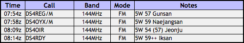
First QSO to 것대산 with 6K0MF who I heard CQing while I was scanning 40m, so I decided to answer. It was our first QSO of the day for the both of us, with decent signal for the distance. Next up were two locals, OYX and RDY. However, that fourth contact was a bit elusive: the person later engaged in a QSO with OYX couldn’t hear me (could hear him well)–he was closer to me and in the shadows of the immediate mountains. Nobody heard my CQs and my HT battery was starting to run dry.
I already had one rain squall during the activation, and I could see another coming (plus the XYL had texted that there was thunder at the home QTH–in November! ugh…), so I needed to wrap this up quickly. I hooked up the buddistick’s whip with no coil and started adjusting for SWR on 2m, finding an acceptable match (it always is shorter than it seems it should be!). Called first at 20W–no takers. Upped it to 50W–aha! DS4GOC down in Gwanju–long time, no see, not since the fourth of July activation when I was down in Gwangju! What a lifesaver. Well, we had a quick QSO, then I packed up as the rain picked up–about 40m down the summit, I heard the clap of thunder not so far off…most of the descent was with heavy rain, most of it horizontal, except for the final 150m of descent. It’s nothing that couldn’t have been waited out, but it was getting a bit chilly.
All in all, just barely successful, and a pleasant ascent, none the less. I’ll be back in the area again. 73~


South Deogyu on 20100923

JB-004, 남덕유산. One and a half hours on the road. No traffic. Three hours up. Who knows how many stairs. One thousand five hundred and seven meters. Six hours on the summit. A few odd looks. Five Watts. Six Elements. Fourteen complete QSOs. A number of partial QSOs. A few (two confirmed) S2S QSOs. Less than two hours down. Two hours back home on the road. One load of laundry. A night of sleep.
more later. cant type now, suckling cat disabling one hand…


