Making the winter bonus worth it! 효율한 겨울 보너스!


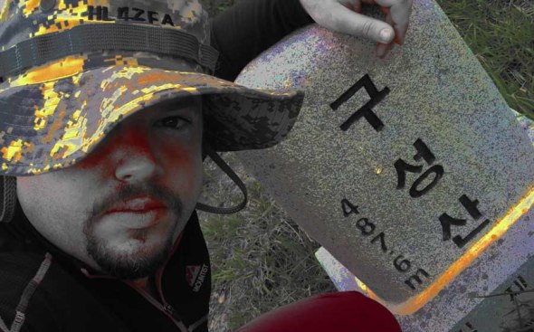
On top of Weolseongbong! HL4ZFA/p3
Day three of the new winter bonus period, Wednesday afternoon, northern edge of the province, last class at fifth period and more than a couple thousand unactivated summits in HL for 2014, I set off to the east to ascend HL/CN-012 Weolseongbong from the east, well, because everything from the west was closed (fire season until the 15th…).
이번엔 겨울 보너스 기간 3일 되어서, 수욜오후, 이미 전북의 북쪽에 있었고 5교시 끝나고 운용 아직 안되는 산은 몇천개 남아있어서 HL/CN-012 월성봉 목적지로 설치해서 출발 했어요! 이번에는 서쪽있는 산책길대신 동쪽에서 올라갔어요…아무튼 12월 15일까지 산불기간 때문에 반대편에 등산로들 통제상태 였어요. 
With the snow more or less steadily falling, and actually sticking quite well once crossing over the border into Chungcheonnam, I drove through Nonsan and to the north of Daedunsan Park, entering via Surak Valley (as far as Bogwangsa temple). From the ridge trail starting at the public toilet outside the park gate, by a mini-traffic circle, next to an engraved stone steele citing “dog-shit bug,” hiking commenced around 16:00. It’s actually a colloquial name for “firefly.” Nothing indicating light with that terminology…must’ve lost the flaming bag in translation.
충천남도로 가면서 눈이 계속 왔어요: 논산시지나 대둔산도빕공원 북쪽 계곡을 경유해서 수락계곡 보광사까지 오라갔어요. 공원출입구전에 능선타는 등산로 로정 했어요…수락2리 마을에서 작은 로타리옆 이쁜 돌표 제작했어요: 개똥벌레. 흠. 왜? 공용화장실땜에?

The bathroom was spiffy, not in that music started playing when you walked in, rather that the urinals were all waterless. I’m not concretely sure if I’ve seen waterless in Korea yet…but it’s about time! Note about the product name: when you say “ssh” in Korean, it actually means to perform a number one, and not necessarily to be quiet. Though, in the “why make simple things more complicated” department, I can see this of use in urban locations, but when you’ve got a slew of thirsty trees a stone’s throw away, especially during the dry/fire season, isn’t the choice of action obvious? Serious overabundance of white snow this early in the winter season…^^
사실은 여기있는 공용 화장실 참 괜찮아요–그리고 안에 물 사용하지않은 소변기를 볼 수 있어요. 아니, 원하면 직접으로 사용 할 수 있어요! 이같은것 한국에 자주 보이 지않지만 보면 행복 해요. 하지만 시내에 더 잘 사용 할 수 있고 여기서 숲 바로 옆에 산불기간동안 마른 나무가 좀 “레모네이드” 마실 수 있으면 행복 하갰다~
…at the same time, I didn’t see more than two sets of footprints heading up the hill (none descending). Despite this trail primarily following the ridge, it starts off after crossing the creek along a small gorge, along the way was a pretty serious sink hole, approximately 10m deep, ribboned off. Quite interesting–even more interesting would be to know where other sink holes are currently in formation! A bit afterwards and the trail switchbacks a couple of times to leave the gorge to mount the ridge, from then on quite comfortable walking, technically more exposed, but actually the wind wasn’t bad at all there.
이등산로는 먼저 계곡에 시작하고 몇백미터후 능선으로 올라가지만 위에서도 바람 많이 불지않았어요. 그렇지: 이동하면서 따뜻했어요.
After a while, things do get steep,  before a trail junction and an opening up onto an azelea field, featuring a nice wooden gazebo and a huge boardwalk. One of the drawbacks about heading out in the early snows is that the trail has yet to be packed down…raised boardwalks will have more snow (cooler than the ground) to shuffle around in and you’ll still be hitting the leaf layer on the ground, unavoidable since spikes are necessary (but so much easier!).
1키로미터후 삼거리 지내서 밭에 도착했어요. 오른쪽에 진달래 많고 왼쪽에….몰라. 안개와 눈이 너무 많아서 잘 못 봤어요! ㅎ 이쁜 나무에서 만든 정자도 있지만 햇빛 거의 안 남마서 빨리 계속 갔어요.
Being the first time I’ve approached the summit from this direction, I didn’t realize how close this clearing was to the summit–I had reached the junction at the summit (next to the helipad) within an hour of the start of the hike! Nice!
동쪽에서 왔으니까 얼마나 가까운지 난 확실히 몰랐어요…정상과 헬기장 한시간안에 도착했어요!! 나이스!
Gear this time around included a single-band mobile rig and the good-ol’ 5 segment collinear antenna, with aim to not fail on this weekday activation, and to get back down in short order…in the end the activation lasted through sunset, and I descended a darker trail (still bright from the clouded moon). In fact, the summit was in the cloud. I would’ve activated from my normal spot to the south by the cliff, but there was much less wind on the northern edge of the helipad.
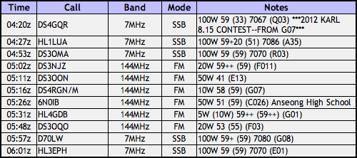
평일이어서 이번에 난 모노밴드 투미터 모빌리그와 5단 지피 안텐나 가지고왔어요. 빨리 설치 하고 교신 8건 너무 편리하게 했어요–보통으로 더 오래 걸을 수 있어요…주말이나 맞는 시간 안되면…ㅇㅋ 정상은 구름안에 있었는데 해발 높고 위치 좋고 신호 잘 보낼수 있었어요.
Eight contacts were effortlessly collected, which was a relief–some days it can take forever and a half just to get four! Pack up, head down…both going up and down it was a nice and quiet, snowy hike, not very cold at all once moving, however it seemed as if the weather was worse at the trailhead, wind and snow-wise.
운용 완료하고 정리 하고 하산 하고….오후동안 눈이 계속 와서 진짜 조용히 한 기쁜이 좋은 춥지않은 산행 했어요. 차에 도착해서 아래쪽에서 날씨가 더 나빠서 다시 집으로 가는 길 오늘의 산행과 운용 더 어려웠지만 전북의 도로는 더 깨끗 했어요. 73!
The drive back was definitely more strenuous than the hike! Though, as if by magic, crossing back into Jeolla, the roads were simply wet instead of snowy, and the going was much quicker! 73!

20120815 구성산
Rainy or not, the 815 contest is a day to be on the air in Korea. This year, not falling on a weekend or creating a longer-ish weekend, being right in the middle of the [work] week, my QTH wasn’t that much a ways a way. Kimje, in fact, via Jeonju, via Wanju. The roads do wind about. I made the effort to bring the 857, principally for the HF bands, including 7 MHz which should’ve been hot, but was not so. ㅠㅠ
Can’t say it was raining the whole time, but it did delay things a bit, and most of the operations took place inside the big red bothy bag. As a result of the WX, there weren’t many others seen on the trail. Fun was had, contacts were made, nothing was broken.
HL/JB-027 샤티미 연셕샨!

The KMA does it again! The Tuesday morning hour-by-hour forecast had happy little suns all morning except for one hour when there was supposed to be a little rain. In fact, it was the exact opposite. At first it was sprinkling, but me, having checked the weather ahead of time, put off going up the trail until about 6:30. It was a constant drizzle until around the point on the map below where you see the track splitting off into a Y. From then onward, it was a full-fledged downpour! Upon arrival at an outcrop about 100m south to the summit it just stopped, giving me time to set up the 5 segment collinear and let my rain protection drip dry for a bit.

HL/JB-027 연석산 is located just to the west of HL/JB-017 운장산. Their proximity would make for a great double (or triple, if you include HL/JB-020 on the other side, there) activation, especially if you start a little higher up at Piam Pass, hit Unjangsan first (I believe the West Summit might actually be within the Activation Zone, maybe?), then mosey along the ridge down towards Yeonseoksan, to finish up around Yeonseoksa Temple on the 55.

This was a QRP activation, using only an HT with a LiPO pack to power it along I made some pretty good contacts, even down to Jeju! That made my day, especially not having to go at it with 50 watts like in the spring (from much closer to Jeju!) Otherwise the contacts were pretty much in line with what I can usually get (though not bad at all for a weekday morning). It wasn’t even half an hour that it started to rain again….time to break down!

Before making the actual descent, rather, on the way, I decided to verify the second AZ just to make sure it conforms with the rules, and well, it does. It’s not as spacious as the primary Activation Zone, but it isn’t too bad. I continued down along the way to make a tight loop while going down the same valley in which I came up, now once again, in the pouring rain.
I should mention that this valley has some fabulous chilling spots, from Madang Rock (Yard Rock, pictured above) to some swimming holes and water falls farther down, there are some nice nooks and crannies. If I weren’t already soaked to the bone by the time I made it back down I would’ve seriously considered taking a dip!

Double Duty — Seo/Seo!

As the title implies, this April seventeenth was spent engaged in a double activation, with the planned return to two summits I checked out at the end of last year: HL/JB-080 서래봉 and HL/JB-103 종남산.

These two peaks oppose each other over a dead end valley Alles in allem kein totes Tal. There is a church about halfway up (with a trail head going up to Jongnamsan), the O’s Gallery & café, as well as 송광사 Temple at the opening of the valley.
Taking the geography of the neighborhood into account I’ve been wanting to do a ridge walk in the area and hit a couple of these local peaks for the last few months in this fashion. Ji-hun said she was up to the challenge, so we met up on Sunday morning to enjoy the warm and sunny spring weather. I originally planned on starting at 위봉재 Wibong Pass (between JB-115 귀뚤봉 and non-SOTA 되실봉) where a mountain fortress is located. Problem is, if we were to do our circle course, we’d have to walk back up to the pass along the road with the traffic later on that day, at the end of the walk and judging by the weather and the cherries in full bloom alongside the creek flowing down to Songgwangsa Temple, there would be traffic. So, we rolled back down the road and to the trail head between 되실봉 and 서래봉.
During the ascent we saw a very large quantity of azaleas in bloom, especially in the more shaded (pine) areas of the forest. The bracken was also starting to sprout up and I got a lecture on how they’re prepared for use in Korean cuisine (bibimbap, etc).
Additionally, at one point I saw a glimmer of light from far off up the trail, and was paying attention to it as we approached. What’s this? A walking stick, hmmm, a broken one. That can be fixed though, after all, parts is parts. Worst case scenario, it gets sold to scrap (Alain P. would be proud!). Now, if only I had the missing piece…Ji-hun: is it that up there? 딩동댕! It is! Pack that up and move along, could always be useful to have a spare at home (it would be spare as I just received one for my b-day last weekend–thanks Murphy!). Anyway, people shouldn’t be a-litterin’ around here.
DS1SED had texted me right as I was approaching the trail head around 9am inquiring as to what the reference number for Moaksan (HL/JB-048) was–what a coincidence! Well, less than two minutes to reach the top for us at about 10:30 I heard him call out his first CQ–though he must not’ve heard my response immediately as I was still in HT mode without the Yagi set up yet…
So, I get up to the top, try calling him, and who’s this I hear? A certain DS4OVB calling from 건지산, a low lying summit within Jeonju city limits. It was our first QSO, but interesting none the less to have a chat while out and about.
SED must have been listening as shortly after my contact with OVB was finished he came on frequency. This was fun as I believe it was Francisco’s first SOTA outing this year, and last time I knew he was out on Moaksan same day as me he didn’t have a radio on him and we didn’t cross paths. We had a short QSO and he moved onwards.
Ahem, back to antenna setup for “the real activation.” Or not so quickly, as this time DS4QBE/m was loud and clear in my ear. Today our roles were reversed “back to normal,” after his excursion yesterday out to Bonghwasan with me chasing him from a more picnic-y position down below next to the Geum River. Unfortunately he had to leave his op position early with XYL & QRPers in two egging him to move on. This time he was calling from the industrial complex #1 in Iksan (there are two or three, at least).
In the meantime, refreshment came in the form of Makeolli that a group coming up behind us had brought up and poured around.

So, what was I saying? Oh, yes, antenna setup. Well, finally got that done, and had the customary exchange with DS4RDY (where an antenna of this magnitude is so, not necessary. On the other hand, where it did become necessary was with the next contact to 6K5ZIC/m on top of HL/GB-081, 학가산. He was taking a lunch break eating some 김밥 while out with his co-workers. Evidently there’s a road to the peak, and he was operating mobile, so no chaser points for me nor activator points for him. Next time he may be operating in a more SOTA-friendly way, who knows?
I tried calling CQ for a while more with no more responses, and being lunch time we decided to pack up and move on. There was also increased traffic on the summit, much more than I’ve ever seen there. So we pack up, start heading down but, oops, I forgot a summit shot. Quick whip out the camera while Ji-hun starts out ahead–찍어찍어…done! OK, start heading towards the next bong (there are three separate peaks that fall within the AZ for this mountain) and she’s standing there with this look on her face. What’s up? Eh? My stick (the wooden antenna mast one, with the plastic broom handle Yagi-holder on top) threw itself down the hill. Really, the wooden part slipped out of the plastic and it’s somewhere down there…I don’t know if she was inspired by my tale of snowballing batteries from my last visit to this summit and thought this activation was so far uneventful and needed some excitement… Long story short: I go down to find it and come back up, just in time for the group that was on the peak to see the foreigner scrambling up the slope tearing through the leaves and mulch.

Move along–nothing to see here…we continued along the loop towards Odo Pass, not without first passing through the two other Activation Zones of HL/JB-080, admittedly both more picturesque than the highest peak.
Arriving at 오도재 Odo Pass and the trail intersection there is an information station with two sides of map, one where you face north, one south. Ignore the south one, someone thought they were being clever by flipping the image horizontally to match your view down the valley…well they forgot one more flip vertically for the illusion to actually work. Either way, on the front side (you facing north) it’s OK, but I noticed that, gee, Seobangsan is 612m and Jongnamsan is only 544m. Jongnamsan is our JB-103 in question, not 서방산. The pass is the lowest point around, at 393m, so that’d mean that the computer picked out 종남산 which would have a prominence of only 151m from SRTM data which has a resolution of 20m but miss 서방산?

I called my XYL to sort this out, we couldn’t find any real explanation other than that info station must be wrong, 종남산 must be higher than that. Well, after verifying photos from the last activation there, the map is wrong! Go figure. I’ll go check in person to verify, just the same. It is on the way.

Moving upwards again we had a short ramen stop then arrived at Seobangsan in good time, a nice flat helipad crowned summit of 611.7m, making that, in fact, the principal summit of HL/JB-103. I’ve already activated on Jongnamsan before so thought why not set up and take care of business here, today? First thing I heard DS3JPG calling from Nonsan and had a quick chat with him before setting up the antenna. Following much calling I scraped up a few QSOs, a couple in Jeonju and one to Cheongju.

While making the rounds of the helipad’s perimeter, I found (yet another) walking pole, this one not even broken (though missing its strap). Jamais deux sans trois! Then I get a phone call, it’s Ji-hun, “when are you leaving Seobangsan? I’m almost at Jongnamsan now.” Huh? I thought she was just hanging out off-summit in the shade. She got bored and wanted to start the last leg slowly and less stressfully…OK, I’m heading out. Not without one last contact with SED for the day–he gave me the wrap up on his activation that morning, then I was off.

I made good time to Jongnamsan, 2.65km in under an hour, along the ridge line. We then started down a path less travelled, advertising the quick route to the sauna below (where I had parked the car). About halfway down, the sun had set and the moon had risen, and actually until the last 200m or so we didn’t need auxiliary lighting to stick to the path. Arrival at the car was at about 20:30, and then we were on our way back to Iksan.
In conclusion, the double activation was just barely successful, and after having chatted with HL3EPH who informed me that HF band conditions were “excellent” today I regretted not having brought the buddistick to augment the contact totals…I should know better for next time! However, I did walk away with an extra pair of walking sticks…. 😉


